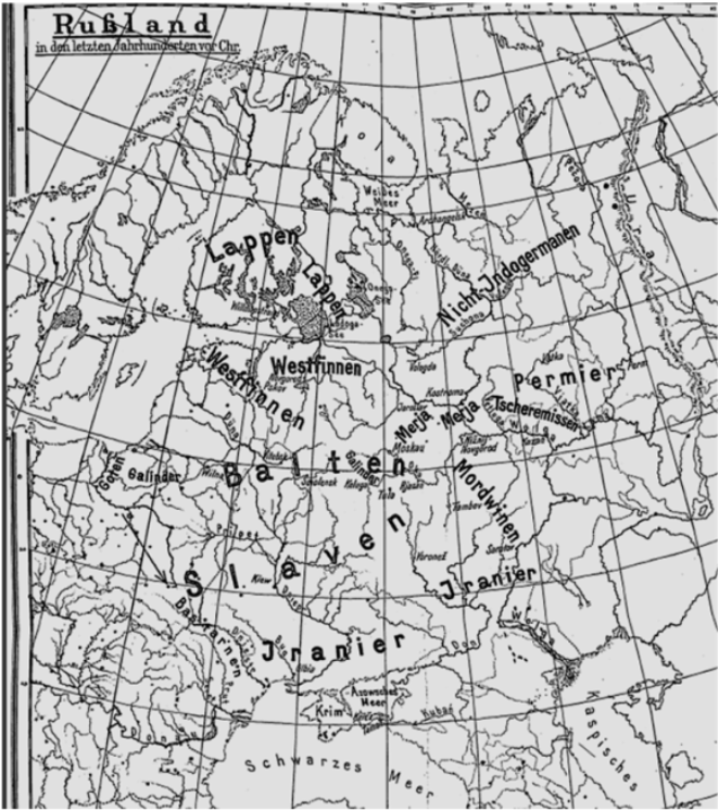
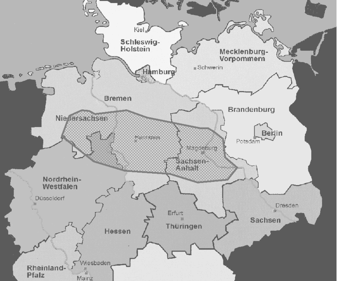
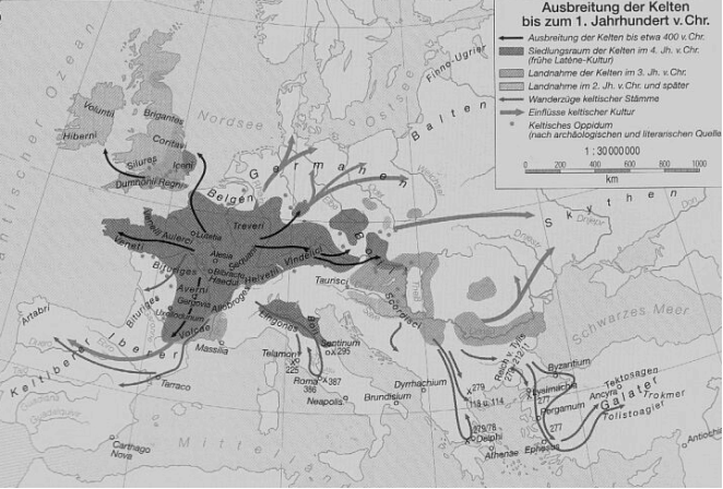
2. Spread of Individual Indo-European Languages in the Light of Names
a.) The Slavic
Efforts to use geographical names to gain more information about the oldest settlement areas of the Slavs are still essentially based on Max Vasmer's “exclusion method”. He succeeded in delimiting the originally Slavic area by separating out all territories in which a Ugric, Iranian or Baltic substratum can be found in place names (Vasmer | [95] | Vasmer, M. (1971): Schriften zur slavischen Altertumskunde und Namenkunde, hrsg. v. H. Bräuer, Bd. 1, Berlin-Wiesbaden. |
| [60] | Toporov, V. N.; Trubačev, O. N. (1962). Lingvističeskij analiz gidronimov Podneprov'ja, Moskva. |
| [62] | Trubačev, O. N. (1968): Nazvanija rek pravoberežnoj Ukrainy, Moskva. |
The decisive progress that goes beyond M. Vasmer's method is due to the research of H. Krahe, although he had hardly dealt with Slavic name material. But he recognized what the basic principles of naming river names lie ‒ and this insight applies not only to the pre-individual language names that H. Krahe prefers to treat, but also to the names of rivers in general and in all languages: H. Krahe
| [32] | Krahe, H. (1964): Unsere ältesten Flußnamen, Wiesbaden. |
[32]
(S. 34) wrote: “With regard to semasiology and etymology, the original and undoubtedly The oldest layer of names consists of so-called 'water words', i.e. names for '(flowing) water', 'source', 'stream', 'river' (or 'flow'), '(water) run' (or 'to run') and the like, with countless finer and subtlest shades of meaning, such as were available to early man in his precise observation of nature...". And in addition to this, H. Krahe says on the question of how one can determine the former residences of a people in more detail: “For where place names of a certain language are found in large numbers, the language in question must also have been spoken, and relatives must have been spoken of the people who spoke this language"
| [32] | Krahe, H. (1964): Unsere ältesten Flußnamen, Wiesbaden. |
[32]
(S. 25).
If you apply these ideas to the question of the homeland and expansion of the Slavic tribes, you will get clear and, in my opinion, unambiguous answers. I have already published the following statements in several places
| [91] | Udolph, J. (2016b): “Expansion slavischer Stämme aus namenkundlicher und bodenkundlicher Sichtˮ. In: Onomastica 60, 215-231. |
| [92] | Udolph, J. (2016c): “Heimat und Ausbreitung slavischer Stämme aus namenkundlicher Sichtˮ. In: Die frühen Slawen - von der Expansion zu gentes und nationes. Teilband 1: Beiträge zum Schwerpunktthema, Langenweissbach, 27-51. |
| [93] | Udolph, J. (2023): “Home and Spread of the Slavs and a New Bibliographical Collectionˮ. In: International Journal of Language and Linguistics 11(4): 136-147. |
[91-93]
, so in the following I only offer a selection of extensive collections and mappings.
First, a comment on the question of whether something can be learned about the homeland and spread of the Slavs from an archaeological perspective. This problem is related to another question, namely the extent to which one can speak of Slavic tribes for the time around the birth of Christ. How can you recognize them or how do you define “Slavs” or “Slavic” for this time? If I have understood Brather's
| [10] | Brather, S. (2004): Ethnische Interpretationen in der frühgeschichtlichen Archäologe, Berlin. |
[10]
study correctly, then from an archaeological point of view it is extremely difficult, if not impossible, to identify a tribe or an ethnic group with the help of material culture or to find or describe their residences and migrations. And from the perspective of linguistics, one must also remember that it is actually impossible to describe where Slavic tribes settled before the turn of the century. This is because before the birth of Christ there was no language that could be described as “Slavic”. The “Slavic”, i.e. the common linguistic features of a language community that emerged from a presumably Indo-European (or Indo-European) dialect area, had to first emerge. This was a process that certainly lasted several centuries. Therefore, you should try with great skepticism attempts to determine something about a people from an archaeological perspective, with the help of genetic research, folklore or historical science that can ultimately only be defined with the help of language. In short: from my point of view, the question of the homeland and expansion of Slavic tribes can only be fruitfully approached by taking linguistically, linguistic and, above all, onomastic arguments into account. In other words: the homeland of Slavic tribes is to be found where, in a dialect area of Indo-European speakers, linguistic similarities that were unique to that dialect area developed in a process that lasted centuries. One should follow an old opinion of M. Vasmer
| [95] | Vasmer, M. (1971): Schriften zur slavischen Altertumskunde und Namenkunde, hrsg. v. H. Bräuer, Bd. 1, Berlin-Wiesbaden. |
[95]
(reprint from 1930!), who was convinced that “the Slavic original homeland question should be solved primarily... through loanword and place name research and as completely as possible consideration of all old historical and geographical sources [can be supported]”.
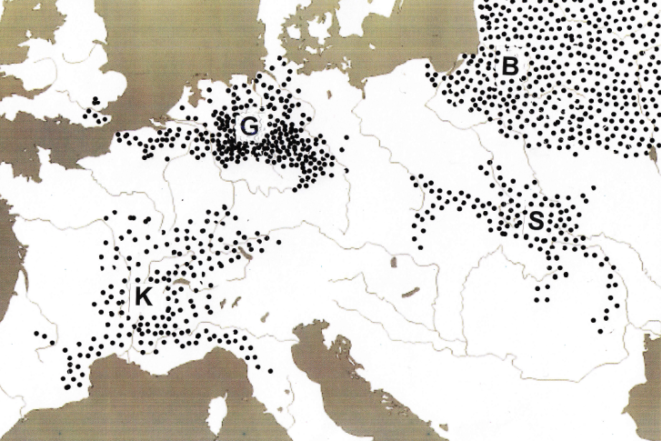
Back to H. Krahe’s “water words” from a Slavic perspective. How can one work out from the former and current Slavic settlement area, which covered or covers a large territory, the area that could be the starting point of the Slavic expansion, the size of which even amazed the Byzantine historians? The great expansion of the Slavs observed by experts and contemporaries (according to a Byzantine source, 100,000 Slavs are said to have invaded Thrace and Illyria in 577 AD) must have started somewhere. This can only have happened north of the Carpathians, i.e. in an area that was not readily known to the ancient sources.
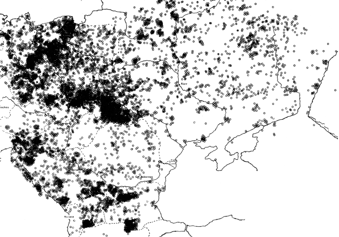
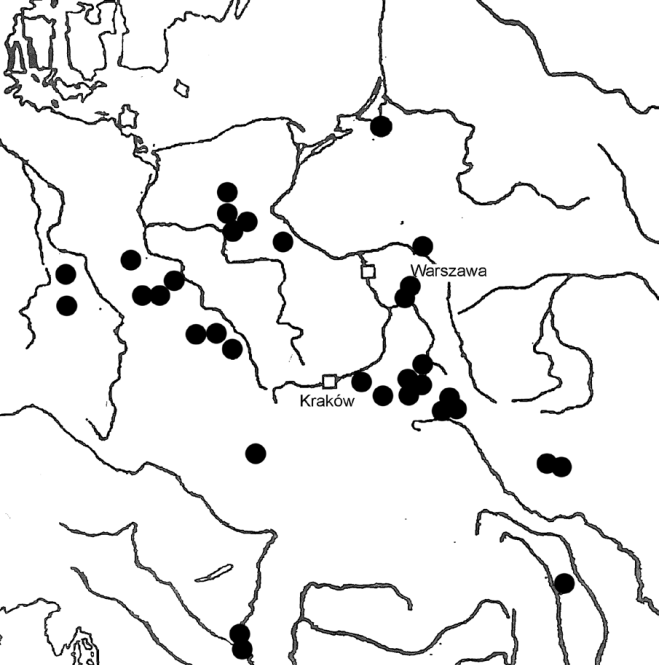
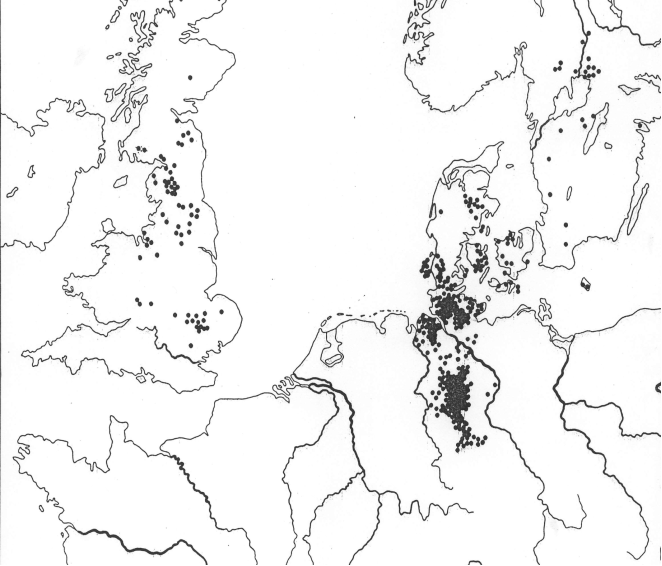
A summary mapping of four dozen Slavic water words and their occurrence in water, place and field names (
figure 2) makes it clear that the area can be delimited quite well: since the area south of the Carpathians and Beskids is excluded, according to the consensus view the clusters in Ukraine and Poland are of particular importance. On the thesis of O. N. Trubačev
| [63] | Trubačev, O. N. (1982-1984): Jazykoznanie i ėtnogenez slavjan (Drevnie slavjane po dannym ėtimologii i onomastiki). In: Voprosy jazykoznanija 1982, 4: 10-26, 5: 3-17; 1984, 3: 18-29. |
[63]
, according to which Pannonia is also a possibility, see Udolph
| [68] | Udolph, J.. (1988): “Kamen die Slaven aus Pannonien?ˮ. In: Studia nad etnogenezą Słowian (Festschrift f. W. Hensel), Wrocław usw., 168-173. |
[68]
.
There is a widespread opinion that Slavic hydronymy shows a certain uniformity. Since the construction and formation of Slavic water names developed according to the same criteria as in the vocabulary, this is entirely understandable, because in these languages derivation is predominant, i.e. formation with suffixes. The following elements are widespread in the names of bodies of water (for details see
| [65] | Udolph, J.. (1979): Studien zu slavischen Gewässernamen und Gewässerbezeichungen, Heidelberg. |
[65]
(S. 539-599).
Figure 2. Synoptic summary of 37 distribution maps of Slavic water words (Source: Udolph 1979: 322, map 40).
Formations with *-(j)-ač-, expanded with the help of -ov- or -in-, cf. Vod-ač, Il-ača, Gnjil-ov-ača, Il-in-jača; *(j)ak, also as -ьn-ak-, -in-ak- and others, is found, for example, in Solotvin-ak, Gnil-jak, Bagn-iak, Glin-iak, Vod-n-jak; -at-, often expanded as ov-at-, e.g. in Il-ov-at, Sychl-ov-at, Hlin-ov-ata; Typical of Slavic hydronymy is –ica, often expanded as -av-ica, -ov-ica, -in-ica, -ьsk-ica, there are numerous formations with -(ь)n-ica, cf. Bar-ica, Glin-ica, Kal-ica, Vod-ica, Vir-ica, Topol-ov-ica, Blat-ьn-ica, Dubr-ov-n-ica, Lis-n-ica, Izvor-st-ica; Relatively common is also -ik-, sometimes extended as -(ь)n-ik-, -ov-ik-, e.g. in Brn-ik, Bah-n-ik, Brus-n-ik, Glin-ik, Il-n -ik, Jam-n-ik, Lip-n-ik, Il-ov-ik; Mostly of adjectival origin are formations with -in-, ina-, -ino-, for example in Berlin, Schwerin, Genthin, which are also found, for example, in the names of bodies of water: Ozer-in, Bolot-in, Vod-in-a, Bar-n- in, Bab-in-a, Dobr-in, Radot-in-a, Slatina, with -ev- and –ov- expanded into Bobr-ov-a, Buk-ov-a, Dub-ov-a, Kalin- ov-a, Lip-ov-a, Vugr-in-ov-o, among others; Water names with -isk- are found almost exclusively in West Slavic: Wodz-isk-a, Bagn-isk-a, Zdro-isk-o, otherwise *-iskio predominates, East Slavic as -išč-, otherwise also appearing as -išt-: Ples -iszcze, Zleb-išče, Rič-išče, Gnój-išča, Bar-ište, Lokv-išta; -ev-/-ov- is also occasionally encountered as a toponymic word formation, e.g. in Duna-ev, Il-ów, Borl-ov, Sopot-ov-o, Bagn-iew-o and others; *-ьc- is very common, sometimes extended with -in-, -ov-, av- and other elements, cf. Izvor-ec, Strumien-iec, Jezer-ca, Blat-ce, Bar-in-ec, Mor -in-cy, Il-ov-in-ce, Hlin-ov-ec, Strug-ov-ec, Brnj-av-ac; The same applies to -ъk-/-ьk-, cf. Potocz-ek, Vir-ok, Dunaj-ek, Ozer-ko, Bagien-ko, Bolot-ki, Vod-n-ev-ka, Il-av -ka, Ozer-ov-ka, Bar-ov-ka, Sigl-in-ka, Zvor-yn-ky, Hnoj-en-ki, Klucz-ew-at-ka, Gnil-ič-koe, Kal-n -ic-ki, Reč-ul-ka; Adjectival formations with *-ьn-, -na, -no are also common: Bar-na, Brez-na, Les-na, Sol-na, Sopot-na, Svib-no, Slatin-ny, Rzecz-ny, Hnój -ny, Il-na, Glin-na, Kal-ne, Zdroj-no.
If you look for formations with these elements in the Slavic body of water names, you will see different distributions in the water words formed with them and often and generally known in the Slavic languages, but centers also form that require interpretation. Here are some examples:
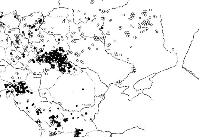
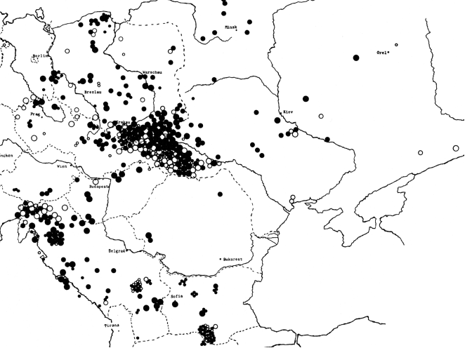
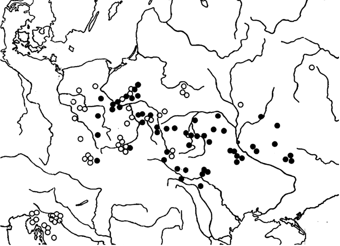
Figure 3. Spread of place names containing Slavic reka ‘river’. Black filled circles immediate formations; white circles suffixed formations; The size of the symbols is staggered according to water, place and field names (Source: Udolph 1979: 257, map 26).
Figure 4. Spread of place names containing Slavic potok ‘stream’; black filled circles immediate formations; white circles suffixed formations; in the size of the symbols, staggered according to water, place and field names (Source: Udolph 1979: 251, map 25).
In order to filter out older types from the abundance of Slavic water names, several criteria can be identified that are characteristic of old and older formations, as has been recognized in recent years
| [71] | Udolph, J. (1997): “Alteuropäische Hydronymie und urslavische Gewässernamenˮ. In: Onomastica 42: 21-70. |
| [72] | Udolph, J. (1998): “Typen urslavischer Gewässernamenˮ. In: Prasłowiańszczyna i jej rozpad, Warszawa: 275-294. |
[71, 72]
.
(1) They contain ancient suffixes that are no longer productive today.
(2) They are of greater antiquity if they are derived from appellatives that are unproductive today.
(3) They are based on different ablaut phenomena, but their areas partially overlap.
(4) They are derived from pre-Slavic, i.e. Old European, hydronyms with Slavic suffixes.
Based on the current distribution of Slavic languages and the distribution maps of Slavic water names shown above (
figures 2-4), parts of Russia and Belarus, Ukraine, Slovakia and Poland are particularly interesting.
Further materialis offered below, including mapping, for the individual points.
(1) The names contain ancient suffixes that are no longer productive today. First of all, the typical hydronymic suffix -ava, -awa should be mentioned here, which gives us, for example, Vir-ava, Vod-ava, Il-ava, Glin-iawa, Breg-ava, Ljut-ava, Mor-ava, Orl-java and encountered other names. It is probably the most typical ancient Slavic suffix in hydronymy and has clear connections to pre-single language, Indo-European naming (Lupawa, Morava-March-Moravia, Orava, Widawa). Occasionally a safe separation is not possible (for the details of the material collection see 65: 555-558).
A mapping of these names (see
figure 5, below) shows that the distribution of these old names mainly covers the area north of the Carpathians, exactly the territory that was already noticed by potok, reka (
figures 2, 3).
Figure 5. Spread with the suffix -ava formed Slavic water names (Source: Udolph 1997: 51, map 3).
Ancient Slavic words and names are so-called
-ū-stems, which usually appear as
ev- or
va (not as
-ava). From the inventory discussed in detail elsewhere
| [65] | Udolph, J.. (1979): Studien zu slavischen Gewässernamen und Gewässerbezeichungen, Heidelberg. |
[65]
(S. 35-47), the only names ot mention here are:
Bagva, Mokva, Goltwa, Mostva, Polkva, Branew/Brnew, Mała Pądew/Malapane. It should be mentioned that these names can often be connected to Slavic words, but some of them cannot, i.e. they cannot be connected to the Slavic vocabulary. This means that some of them are likely to be older. This is also supported by the fact that in the Baltic body of water names there are formations with very similar suffixes such as
-uv-, iuv- and
-(i)uvė, -(i)uvis; here only briefly to mention are:
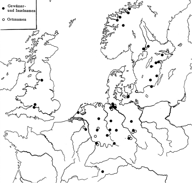
Daug-uva, Lank-uvà, Alg-uvà, Áun-uva, Gárd-uva, Lat-uvà, Mìt-uva, Ring-uvà, Týt-uva, Vad-uvà, Várd-uva, Gil-ùvė, Audr-uvìs, Med-uvìs, Dìt-uva.
The spread of names (the Baltic ones remained away) shows (
Figure 6) that once again a band stretching from west to east extends from central Poland through southeastern Poland to the area east of Kiev, although the Carpathians are not exceeded to the south.
Figure 6. Spread of Slavic water and place names; ● = so-called (ancient) -ū-tribes in geographical names; ○ = Slavic Ponikla, Ponikva, Ponikiew etc. ‘disappearing, underground river’.
In the map are included the names derived from Slavic
ponik, ponikva “disappearing river, underground watercourse” (detailed in
| [46] | Rozwadowski J. (1948): Studia nad nazwami wód słowiańskich, Kraków. |
[46]
(S. 239-245), which also reflect an
-ū-tribe, but are of much more recent origin. This is also documented by the mapping, because the focus is on the ancient
-ū-formations (some of which are etymologically transparent), while
ponik(va) is clearly evident in areas reached by Slavs more recently, such as Slovenia (here it is a term for the karst landscape), Middle and Western Poland and Belarus can be found. The Northern Carpathian region once again turns out to be an ancient Slavic settlement area.
(2) Slavic water names are more ancient if they are derived from appellatives that are unproductive today. In other words, this means that the language from which the corresponding water names were created must still have possessed the word hidden in the names. So these are undoubtedly older Slavic names. From the numerous cases available, a few have been selected.
What is impressive here is the spread of names such as
Bagno, Bahenec, Bagienice, Bagienek, as well as the surname
Baginski, which can also be found in Germany, which can be combined with Ukrainian
bahno, Polish
bagno “swamp, moor, morass”, etc. The word has been missing from South Slavic for a long time; it seems to have disappeared from this area at an early stage (for details, the vocabulary in the Slavic languages and the names derived from them, see
| [65] | Udolph, J.. (1979): Studien zu slavischen Gewässernamen und Gewässerbezeichungen, Heidelberg. |
[65]
(S. 324-336). As
figure 7 shows, corresponding names can be found primarily in the West Slavic region.
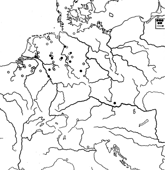
Figure 7. Distribution of place names that contain Slavic bagno “morass, swamp”; Black filled circles = immediate formations; white circles = suffixed formations; The size of the symbols is staggered according to the name of the water, place and field (Source: Udolph 1979: 334, map 42.
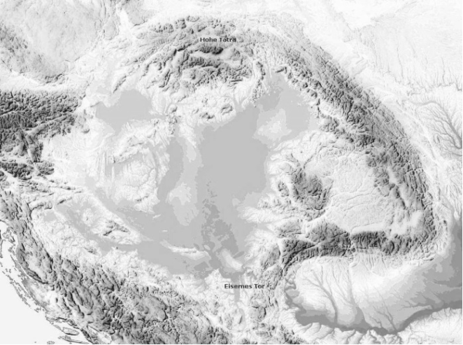
Figure 8. Course of the Carpathians.
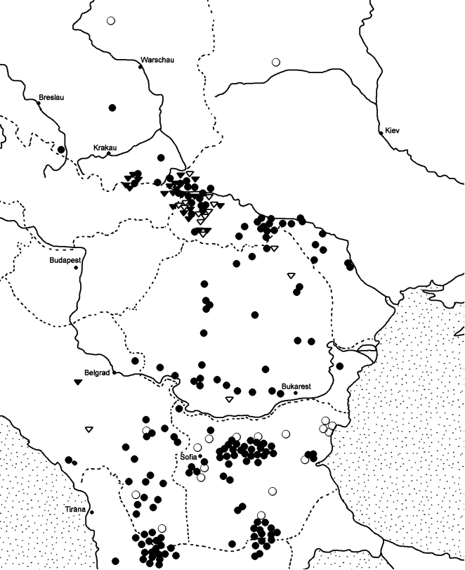
All the more remarkable is the radiation to the southeast, clearly based on the northern and eastern slopes of the Carpathians (see
Figure 8), until then, approximately in today's southern Romania, the word disappears from the active vocabulary and the last names formed with it at the Iron Gate have left their mark. This expansion clearly shows one of the routes of entry of the later southern Slavs into the Balkans.
Another important observation that is crucial to the question of the ancient residences of Slavic tribes has to do with the fact that the Slavic language area is now separated by Austria, Hungary and Romania: for centuries there has been no separation between West and East Slavs in the north and the South Slavs in the south close contacts more. The separation between the two Slavic residential areas naturally led to the development of South Slavic peculiarities that remained unknown to the Slavic languages north of the Carpathians. There are cases in which this discrepancy in vocabulary is clearly visible, but the stock of names shows a different picture.
There are appellatives, including water words, that are unique to South Slavic, but - and this is the crucial point - also appear in names north of the Carpathians. Before resorting to an interpretation of this phenomenon, The relevant material is available here.
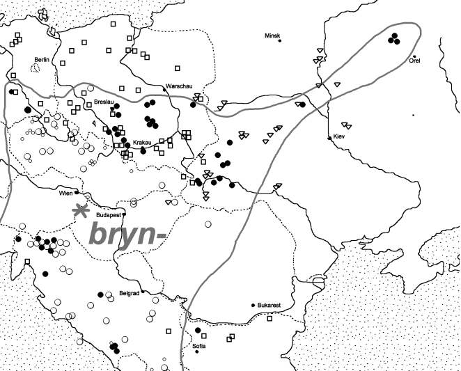
The long-controversial basic form of the Slavic clan around Old Serbian brna “'excrement, earth”, Bulgarian Church Slavonic (Middle Bulgarian) brьnije “excrement, clay”, Old Church Slavonic brъna “excrement”, Slovenian brn “river mud” etc. is resolved perfectly when the onomastic material is included (for details see 46: S. 499-514). A *bьrn- approach is often suggested, but West Slavic and especially East Slavic water names such as Brynica, Brenica, Branica and Bronica, Bronnica, Brono speak against it. In addition, in the name treasure north of the Carpathians, in addition to the aforementioned *brъn- < *brŭn-, the ablaut variant *bryn- < *brūn- can also be found (Brynica, Brynówka, Brynec). Slavic *bryn- requires an approach *b(h)rūn- and meets easily with Germanic *bhrūn- in Low German brūn-, High German braun, English brown.
This example is important in two ways. On the one hand, it becomes clear that it is a South Slavic word group that, although missing from the Slavic vocabulary north of the Carpathians, has left its clear traces in the names there. There are two ways to explain this. On the one hand, one can assume that the word family developed separately in South Slavic and that South Slavic groups then moved north and left their South Slavic peculiarities in the names. This is an extremely complicated assumption, especially given the fact that the brn-, bron-, bryn-names are also widespread north of the Carpathians. The second possibility is that the existence of the names north of the Carpathians is taken as evidence that the underlying words were known to the vocabulary of the Slavs who settled there and that the names were created from them. One can only conclude from this: the names found north of the Carpathians do not come from a single Slavic language - not even from South Slavic - but from a precursor to all Slavic languages, i.e. from Proto- or Common Slavic itself.
This is strongly confirmed by the fact that the beginnings *brъn- and *bryn- are reflexes of an old ablaut (more examples follow below), which also only has to come from an old Slavic language level.
If you now add the spread of the names and realize that both ablaut variants in the name inventory only occur side by side in a certain area of the Slavic languages, you get another solid argument for the fact that here - roughly speaking: in southern Poland and western Ukraine (in Bohemia, Moravia, Slovakia and in Slovenia there is only one variant) - the home and the starting area of the Slavic expansion must be sought.
(3) Ancient Slavic water names can still be determined by following the traces of the ablaut. There are ablaut phenomena in almost all Indo-European languages, here are only mentioned singen - sang - gesungen, bieten - bot - geboten; English sing - sang - sung; Lithuanian žalias “green” - žolė “grass”; Greek lego - logos; Slavic tek- “flow” - tok “current” (also in potok, see above).
However, traces of ablaut in Slavic - in contrast to Germanic - can only be found to a limited extent, so that only a few relics can be expected in hydronymy. However, these are of very special value and therefore their occurrence and distribution should be given particular attention. We have already discussed *brŭn- > brn-, *brūn- > bryn- above. Other important cases follow here.
For Proto-Slavic, a word
*jьz-vorъ can be used with the meaning “source, lowland, stream valley, spring, whirlpool”, which is found in Old Russian
izvorъ “source”, Ukrainian
izvir “small mountain stream”, Serbian, Croatian
izvor “source, spring, whirlpool” lives on. This word contains an ancient composition, because Slavic knows the verb
vъrěti” 'to bubble”, but not an independent
*vor- (for word and name material see
| [65] | Udolph, J.. (1979): Studien zu slavischen Gewässernamen und Gewässerbezeichungen, Heidelberg. |
[65]
(S. 163-170), cf. also
| [54] | Schmid, W. P. (1994): Linguisticae Scientiae Collectanea. Ausgewählte Schriften, Berlin - New York. |
[54]
(S. 260f.).
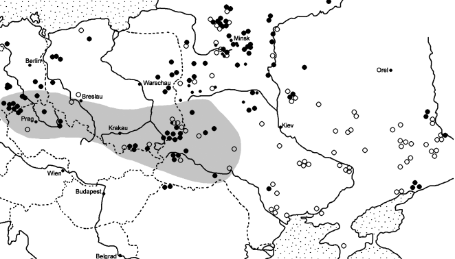
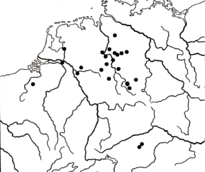
Figure 10. Distribution of place names containing Slavic *jьz-vorъ “source, fountain”; circles and Triangles symbolize the different developments in the Slavic languages (izvor or zvor), graded in size according to water, place and field names (Source: Udolph 1994: 169, map 13).
Therefore, the distribution of names (Map 10) is of particular importance. The assumption that the occurrence in the Carpathian and Beskid region could be an extension of a younger, South Slavic name is not possible in view of the ablaut inherited from the Indo-European precursor. Rather, the names in the Dniester and San regions come from a language level that still knew the underlying appellative. This can only have been a preliminary stage of the individual Slavic languages, i.e. in other words, a common Slavic or proto-Slavic language layer.
In comparison with the spread of
bagno-names (
Figure 7), this map also shows that the later southern Slavs not only used one route along the Carpathian arch (see
figure 8), but also the southern one on various routes across today's Romania reached the Balkans.
Similar to
*brъn-/*bryn-, names are common that carry clearly recognizable traces of an old ablaut. It's about Belarusian
krynića “small lake; watercourse that emerges from the earth, source”, Ukrainian
krynica “source”, Polish
krynica, krenica”'source, fountain”, which continue a basic form
*krūn-ica (for details see 65: 367-374). There is a so-called expansion stage, which in Ukrainian (dialectal)
kyrnýcja, kernýc'a “source”, Old Polish
krnicza “rivus”, Slovenian
krnica “deep place in the water, water vortex, river depth” has its short vowel equivalent
*krŭn-. If one looks at the occurrence of the
krynica- names, which cover a wide area, and compares this with the spread of the short vowel ablaut variant (
figure 11), an area becomes clear in which both variants occur side by side. The resulting territory can certainly be viewed as an old Slavic settlement area.
Figure 11. Distribution of place names that contain Slavic *krŭn > krъn- or *krūn > kryn (ablau-tending forms) “source, fountain, stream”; Black filled circles = immediate formations; white circles = suffixed formations; The size of the symbols is staggered according to the name of the body of water, place and field. The hatching indicates the area in which only the short vowel *krŭn/krъn variant is encountered (Source: Udolph 1994: 169, map 13).
Attempts to relocate the ethnogenesis of Slavic to the Oka region (Gołąb
| [20] | Gołąb, Z. (1992): The Origins of the Slavs. A Linguist’s View. Columbus (Ohio). |
[20]
), to Asia (Kunstmann
| [36] | Kunstmann, H. (1996): Die Slaven. Ihr Name, ihre Wanderung nach Europa und die Anfänge der russischen Geschichte in historisch-onomastischer Sicht. Stuttgart. |
[36]
) or to the Balkans (Trubačev
| [63] | Trubačev, O. N. (1982-1984): Jazykoznanie i ėtnogenez slavjan (Drevnie slavjane po dannym ėtimologii i onomastiki). In: Voprosy jazykoznanija 1982, 4: 10-26, 5: 3-17; 1984, 3: 18-29. |
[63]
) - on the other hand Udolph
| [68] | Udolph, J.. (1988): “Kamen die Slaven aus Pannonien?ˮ. In: Studia nad etnogenezą Słowian (Festschrift f. W. Hensel), Wrocław usw., 168-173. |
| [73] | Udolph, J. (1999a): Die Schichtung der Gewässernamen in Pannonien. In: Ural-Altaische Jahrbücher, Neue Folge 15, 90-106. |
[68, 73]
must fail because of these distributions. It would be necessary to deal more intensively with these facts, especially since similar phenomena can also be demonstrated for the question of Germanic homeland and expansion (see below). The next case is very similar.
In addition to the well-known Russian appellative
grjaz “dirt, excrement, mud”, which is found in, among other things, Belarusian
hrjaz' “soggy spot on a path, swamp, dirt”, Ukrainian
hrjaz' “swamp, puddle, mud” and Slovenian
grêz “moor, mud” equivalents, and presupposes a proto-Slavic approach
*gręz-, Slavic also knows the Ablaut
*grǫz-, for example in Ukrainian
hruz' “swamp, moor, morass”, Belarusian
hruzála, hruzalo “dirty place, swampy place”, Polish grąz, gręzu”'muddy swamp” (detailed discussion in Udolph
| [65] | Udolph, J.. (1979): Studien zu slavischen Gewässernamen und Gewässerbezeichungen, Heidelberg. |
[65]
(S. 142-152). It should be noted that South Slavic does not have the ablaut form *grǫz-, so it has no part in this Proto-Slavic ablaut variant.
The distribution of names certainly corresponds to this (
figure 12): the names are widely spread, a particular productivity can be observed in East Slavic, South Slavic only has the
*gręz-variant.
Figure 12. Distribution of place names that contain Slavic *gręz-/*grǫz- (ablaut forms) “mud, morass, swamp”); Quadrilaterals = *gręz-; Triangles = *grǫz-; The size of the symbols is staggered according to the name of the body of water, place and field; The hatching indicates the area in which only the *grǫz-variant is encountered (Source: Udolph 1997: 59, map 9).
A homeland of Slavic in the Balkans is therefore completely ruled out (we are talking about proto-Slavic ablaut variants, the productivity and impact of which can be seen long before they penetrated the Balkans). Based on these facts, Slavic can only have developed north of the Carpathians.
In summary, this is supported not only by the word pair grjaz'/hruz just discussed, but also by the previously discussed groups around izvor'/vьrěti, krynica and, above all, brъn-/bryn-, which is due to the secure connection with a Germanic color word is additionally anchored in the Proto-Slavic vocabulary.
(4) The discovery that under a single language layer of water names in Europe (it does not matter whether it is Germanic, Celtic, Slavic or Baltic) there is a network of pre-single language = Old European = Indo-European names opens up new possibilities for the determination of the area in which an Indo-European language developed.
In the Slavic territory, this can be seen primarily in a few but important cases: these are ancient Slavic suffixes that are based on pre-Slavic, Indo-European roots, names or bases. What is important and crucial is where such names are located.
The largest river in Poland, the
Wisła, German
Weichsel, has a clearly pre-Slavic name, no matter how you explain it (see most recently Babik
| [5] | Babik, Z. (2001): Najstarsza warstwa nazewnicza na ziemiach polskich, Kraków. |
[5]
(S. 311-315]; Udolph
| [69] | Udolph, J. (1990): Die Stellung der Gewässernamen Polens innerhalb der alteuropäischen Hydronymie, Heidelberg. |
[69]
(S. 303-311). For the question that concerns us here and now, the tributary of the San
Wisłok, approximately 220 km long, and the approximately 165 km long tributary of the Vistula, the
Wisłoka, are of considerable importance.
With the same suffix are formed
Sanok, a place on the San southwest of Przemyśl;
Sanoka, a water name no longer known today, 1448
per fluvium Szanoka, near the place Sanoka and with a diminutive suffix to
-ok-, which is a tributary of the Sanok, which is called
Sanoczek (for details see Rymut/Majtán
| [47] | Rymut, K.; Majtán, M. (1998): Gewässernamen im Flußgebiet des Dunajec, Stuttgart. |
[47]
(S. 222]; Udolph
| [69] | Udolph, J. (1990): Die Stellung der Gewässernamen Polens innerhalb der alteuropäischen Hydronymie, Heidelberg. |
[69]
(S. 264-270). It is also certain that San is a pre-Slavic name. The different views on the etymology do not change this (see a brief summary of this in B. Czopek-Kopciuch (In: Nazwy miejscowe Polski, t. 13, Kraków 2016: 48). With the suffix variant
-očь, this also includes
Liwocz and
Liwoczka, river names near Krakow; a mountain range of the Beskids is also mentioned in Długosz as
Lywocz.
All names are located in the south or southeast of Poland, exactly in the area that has clearly been identified as part of the Proto-Slavic settlement area by the Slavic words and names that have already been discussed. According to the judgment of Słownik Prasłowiański
| [59] | Słownik Prasłowiański (1974): F. Sławski (Red.), Słownik Prasłowiański, Bd. 1, Warszawa 1974. |
[59]
(S. 92), the suffix
-ok- represents a proto-Slavic archaism. It appears appellatively, for example, in sъvědokъ, snubokъ, vidokъ, edok, igrok, inok, etc., but its antiquity is also reflected in this, among other things that it belongs to archaic athematic tribes. It must be clearly pointed out that - as was often assumed in the past - the existence of pre-Slavic, Old European names in the presumably old or oldest settlement area of Slavic tribes does not speak against the assumption that this was located there, but is the necessary consequence of the fact that The individual Indo-European languages did not develop out of a vacuum, but rather developed, and one might even say, had to develop, on a broad Indo-European basis from a layer of old European names.
Since -ok- is now an archaic suffix, the names mentioned here can be assigned to an older level. They are therefore very likely to be seen as links between Old European and Slavic hydronymy.
Summary - Homeland of Slavic tribes
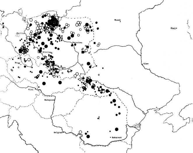
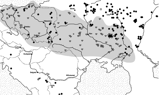
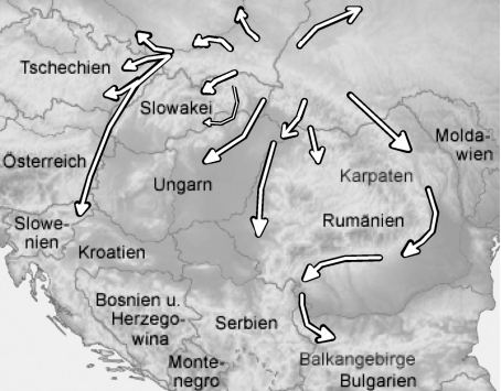
Figure 13. Expansion of Slavic tribes in the light of geographical names (draft).
My summary of the investigation of water names for the question of the oldest settlement areas of Slavic tribes is as follows: the premises required for the question from a linguistic, linguistically and onomastic perspective are taken into account by all the place and water names examined with regard to a possible area in in a very specific area: it is the Pre-Carpathian region. In a simple mapping are summarized the results of the name distribution of Slavic water words and water names (
figure 13). The core of the expansion is an area north of the Carpathians, roughly between Kraków and Bukovina.
However, it must be said with all clarity that the boundaries cannot be as clearly stated as the map seems to suggest. It is an attempt to present the core of the mapping in a simple form. Every mapping of a place or water name type varies; there are hardly any two maps that coincide in their centers or peripheries. But it can be accepted that this assignment makes sense.
This is because there is another aspect that has not yet been addressed in addition to archaeology, genetic research, linguistics and onomastics as well as history: the soil science.
It was emphasized at the beginning of this article that this article was written primarily from a linguistic and onomastic perspective. In recent years, however, it has become increasingly clear - not only in the collection and interpretation of Slavic names - that there is another aspect that apparently has nothing to do with geographical names, but which, as far as we know, is crucial for early: The quality of agricultural soils.
As early as the 1920s and 1930s, attempts were made to associate certain place names with the different quality of the soil. Since then, there have actually been numerous publications dedicated to this topic. A list of the relevant literature is omitted her and only mentioned the work of Schlüter
| [51] | Schlüter, O. (1958): Das mittlere und nordöstliche Mitteleuropa, Remagen. |
[51]
. Recently the opinion has repeatedly been expressed that a connection between soil quality and certain Slavic place name types must be viewed as certain. I pointed this out in detail in the review of a book by Walter Wenzel (Udolph
| [92] | Udolph, J. (2016c): “Heimat und Ausbreitung slavischer Stämme aus namenkundlicher Sichtˮ. In: Die frühen Slawen - von der Expansion zu gentes und nationes. Teilband 1: Beiträge zum Schwerpunktthema, Langenweissbach, 27-51. |
[92]
) and quote a few sentences from W. Wenzel here: “In Upper Lusatia we were able to determine that these four [place name] types only occurred in the central loess areas with the most fertile soils, where the immigrants had first settled... The course of settlement depends to a decisive extent [also on]... the quality of the soil, which can vary quite a bit in Lower Lusatia, even over shorter distances. And even more clearly elsewhere: This can be confirmed “with concrete land value figures from the Atlas of the History and Regional Studies of Saxony... If one compares the distribution of this type of name... with the land value map by W. Stams, the connection between soil quality and name type cannot be overlooked.”
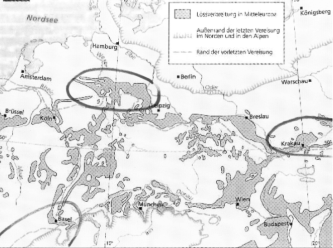
Let us try to transfer these by no means new findings to the soils of Poland and Ukraine. A loess atlas published in 2007 (Haase et al.
| [26] | Haase, D. et al. (2007): “Loess in Europe - its spatial distribution based on a European Loess Map, scale 1:2,500,000ˮ. In: Quaternary Science Reviews 26 (9-10): 1301-1312. |
[26]
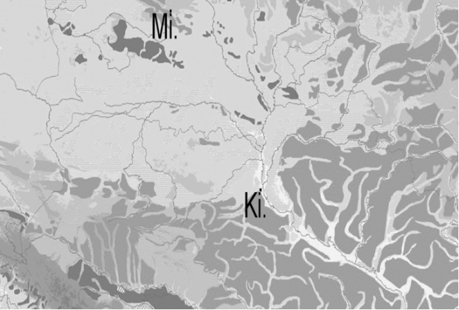
), from which is offered here an excerpt here, has proven to be particularly helpful.
Figure 14. Loess distribution in eastern Poland and Ukraine. Mi = Minsk, Ki. = Kiev, dark gray = loess over 5 m thick (according to Haase et al. 2007).
It makes no effort to correlate the distribution of loess in the Pre-Carpathian region with the old Slavic water names compiled in this article.
Of course, you also have to take into account that loess soils are not always easy to work. My careful attempt to incorporate findings from ancient land research into this question led me to a few studies from which only a few passages are selected here. As a layperson in the field of soil research, it is advisable to be very careful here. But the following comments essentially support my thoughts. Scheffer
| [48] | Scheffer, F. (1978): “Boden in Mitteleuropaˮ. In: Reallexikon der Germanischen Altertums¬kunde, Bd. 3, Berlin - New York, S. 108-117. |
[48]
(S. 116-117) says: “Since the Neolithic, there has been a considerable narrowing of the black earth areas in Central Europe that were then preferred for settlement purposes... Up to the present day, the heavy soils of the loess areas, the young ground moraine landscapes, The marshes and the low mountain ranges are considered to be more favorable for agricultural production than the light soil types, as they have higher reserves of plant nutrients...” And a few pages later, B. Meyer
| [39] | Meyer, B. (1978): “Bodenkunde und Siedlungsforschungˮ. In: Reallexikon der Germanischen Altertumskunde, Bd. 3, Berlin - New York, S. 117-120. |
[39]
(S. 119) says that heavy potassium-rich soils were preferred in the medieval clearing periods despite their heavy resilience.
Nevertheless, a related thought ist expressed here, that comes rom a discussion I had with K. Casemir (Göttingen/Münster) about loess soils and the age of place names. If you take a closer look at the distribution of place names (e.g. in eastern Lower Saxony, relevant from an onomological perspective:
| [13] | Casemir, K. (2003): Die Ortsnamen des Landkreises Wolfenbüttel und der Stadt Salzgitter (= NOB, Band 3), Bielefeld. |
[13]
) you can come to the conclusion that the oldest Germanic place names, i.e. the suffix formations, “are not in the core areas of the loess basins, which are undoubtedly the oldest settlement areas, … but on their edges”
| [13] | Casemir, K. (2003): Die Ortsnamen des Landkreises Wolfenbüttel und der Stadt Salzgitter (= NOB, Band 3), Bielefeld. |
[13]
(S. 410). An opinion by G. Overbeck (quoted in Casemir
| [13] | Casemir, K. (2003): Die Ortsnamen des Landkreises Wolfenbüttel und der Stadt Salzgitter (= NOB, Band 3), Bielefeld. |
[13]
(S. 49, note 212) goes in a similar direction, according to which the preference for poorer quality soil in older settlements is related to the settlers' 'technical' possibilities for cultivating the soil. The more fertile but at the same time heavy soils, such as those found in most Büttel towns, could only be cultivated with improved equipment. For this reason, the better soils were initially hardly used and were only settled at a later date.
Applying this to the loess distribution in western Ukraine and southeastern Poland, it is very noticeable that the center of the Old Slavic names is in the area in which the loess distribution gradually “frays out” (
Figure 14), i.e. approximately in the area west of Kiev between Kraków in the west and Vinnycja and Moldova in the east.
To put it briefly: the distribution of good soils coincides with that of the ancient Slavic names. If this is correct, then one can assume that there is a nucleus - or rather a core landscape - of Slavic settlement in the Subcarpathian region. The existence of pre-Slavic, but Indo-European names and of water names, the structure of which indicates that they arose from an Indo-European basis, but then also developed Slavic peculiarities, can now - as already said above - only be understood in such a way that here, in a process that lasted centuries, the language group that is now called Slavic emerged from an Indo-European dialect area.
Since good soil obviously may have played a role, the following consideration is up for debate here: good soil leads to better harvests, minimizes general and child mortality, and leads to excess population pressure, which can only be alleviated by a gradual expansion of settlement activity can be. The same can be said about the question of the homeland and expansion of Germanic tribes, which I will come to shortly.
The intensive study of the geographical names of Eastern and Central Europe leads to the realization that Slavic emerged from an Indo-European dialect (Old European hydronymy and Baltic-Germanic-Slavic similarities play a role) in a relatively limited area between the Upper Vistula and Bukovina must have developed, a Balto-Slavic intermediate stage could not have existed, there were early, almost continuous contacts with Baltic and Germanic tribes, and the later residences of East, West and South Slavic peoples were reached through strong expansion. Very similar expansions have been observed among Celtic and Germanic tribes, although these preceded the Slavic expansion.
b.) Homeland and expansion of Germani settlers according to the namesc
The development of the Germanic language stem from an Indo-European precursor must probably be placed earlier than in the case of Slavic. Around 500 AD, clear differences in the language structures of Germanic can already be seen, for example between East Germanic (Gothic), North Germanic (Runes, Proto-Norse) and West Germanic. According to most linguists, the development of Germanic as an independent branch can be observed, among other things, in the effect of the first (Germanic) sound shift, around 500 BC. put on. In its effects - contrary to the results of the second (High German) sound shift - this obviously affected all Germanic language branches very uniformly and without major differences. This process must have taken place in a relatively small geographical area, otherwise there would certainly have been greater differences in the sound shift reflexes. Apparently that is not the case. The question is whether the thesis that the Germanic “original homeland” must be found in a relatively small geographical area can be confirmed with the help of the most ancient Germanic place and water name types.
If you deal with old Germanic place names and their formation, you will soon be led to an old but still valid word from Jacob Grimm
| [23] | Grimm, J. (1826): Deutsche Grammatik. Zweiter Teil. Göttingen. |
[23]
(S. 403). He had emphasized almost 200 years ago: “It is the unmistakable direction of later language to abandon derivations and replace them with compositions”. In other words: Derivations, i.e. suffix formations, are usually older formations than compounds or composition formations in Germanic place names. A study dedicated to the older residences of Germanic tribes should therefore focus primarily - although not exclusively - on suffixal formations.
In a comprehensive study of water, place and field names of Germanic origin
| [70] | Udolph, J. (1994): Namenkundliche Studien zum Germanenproblem, Berlin - New York. |
[70]
, this topic was treated in its entirety; A little later, derivations were the focus of further contributions
| [79] | Udolph, J. (2004b): “Nordisches in deutschen Ortsnamenˮ. In: Namenwelten. Orts- und Personennamen in historischer Sicht. Berlin - New York, 359-371. |
| [86] | Udolph, J. (2011b): “Skandinavische Wörter in deutschen Ortsnamenˮ. In: Probleme der Rekonstruktion untergegangener Wörter aus alten Eigennamen. Eigennamen. Uppsala, 141-158. |
[79, 86]
. For Lower Saxony, studies by R. Möller (40; 41) should also be taken into account.
Collections and distribution maps of Germanic water words such as hor ‘swamp, morass’. mar(sk) 'inland lake, swamp', Riede 'bach, flow', from suffix formations with -ithi-, ing-/ ung , -st-, -str- and from place name basic words such as -hude 'ford, mooring place on the water ', *sētjanez/sēt[j]ōz 'settler', kot 'settlement', tun/ton 'city, settlement', tie 'meeting place, court place', sel(e) 'apartment, village, settlement', klint ' Hill, Abhang', wedel 'ford' and many others clearly show that Germanic continuously developed in the continental Germanic area, more precisely: in southern Lower Saxony, in western Saxony-Anhalt and in parts of Thuringia from a clearly recognizable Indo-European substrate.
In order to keep this article within the scope, I have selected just a few distribution cards and provided them with a short comment.
From this central space, early relationships can be seen both to the west (Westphalia, Flanders, northern France, England) and to the north (Denmark, Sweden, further to Norway). Here are a few examples, first of all for relations with the West.
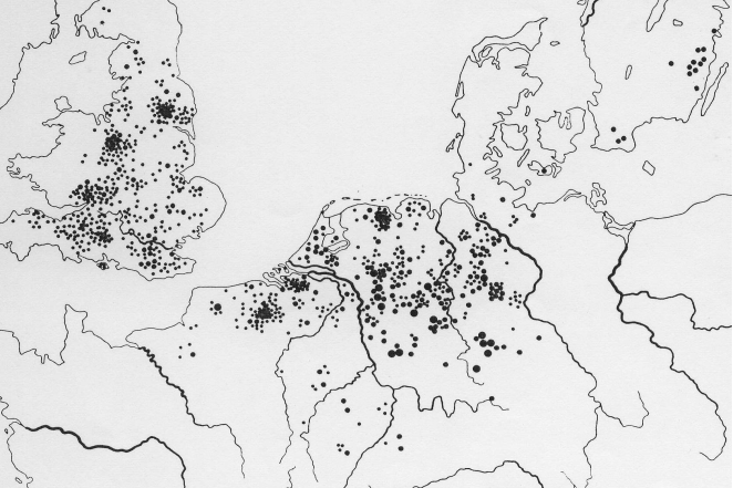
a. German *fani/-ja “swamp, moor”
An old name for "swamp, moor", but also for "low-lying grassland" is found in the Germanic clan around the Gothic fani "mud", usually *fanja is used. There are hundreds of Fenn names; in Germany for example Ackerfenne, Fanhusen, Fehn, Fehnhusen, Venusberg in Bonn, also Venusbruch and Venushügel near Wernigerode, Vienenburg, 1306 date Vineburch. Also morphologically older types such as Finne in Thuringia, 1106 in silva Vin etc.; Viningi and Viningeburg near Lüneburg; -r-derivation in Fiener Bruch near Genthin, 1178 in palustri silva, que Vinre dicitur; Vinnen (Hümmling), around 1000 Vinnum, Finnum; with -str-Formans: Vinster (Oberlahnkreis), 893 (Copy 1222) Veneter, Wenestre, Uenestre, 1312 and others. Vinstern, belong here.
Correspondences are also common in the Netherlands, Belgium and northern France: Bakkeveen; Berkven; Diepenveen, including apa-name Vennep, around 960 Vannapan, Vennapen, and Venepe, 1138-53 Uenepe, 1144 Venepe; also compare Venlo.
There are just as many examples in England: Blackfen, Broadfans, Bulphan, Coven, Fambridge, Fan, Fanns, Fann's, Fen, Fenn, Fennes, Fulfen, Gladfen, Orsett Fen, Redfern's, Stringcock Fen, Vange, Fencote, and place names of the type are common Fenton, 1086 Fentone etc.
The map shows strong occurrence in northwest Germany, on the Lower Rhine, in Flanders and England. Schleswig-Holstein and Jutland are only slightly involved. Once again it becomes clear that the land seizure by West Germanic tribes must have taken place across the canal.
Figure 15. Germanic *fanja in place and field name (Source: Udolph 1994: 315, map 31).
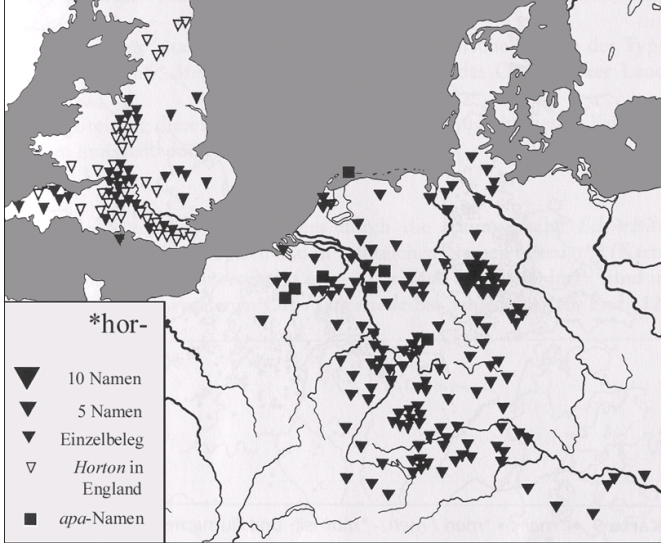
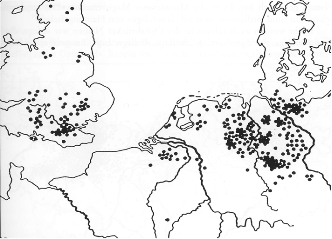
b. So far, little attention has been paid to a word that is well attested in German, Dutch and English: Old High German horo "mud, porridge, dirt, feces, earth", Middle High German hor, hore "swamp ground, filthy ground, feces, dirt, mud", Old Saxon horu “feces, dirt”, Old Frisian hore “mud, feces”, Middle Dutch hore, hor “lutum; Modder”, Old English horh, horu “filth, dirty”.
German place names such as Haarbach, Haarhausen, Harmke, Horbach, Harbrücken, Harburg bei Hamburg, Horb, Horburg, Horchheim, Hordorf contain the word.
From the Netherlands, Belgium, Luxembourg and France belong here: Althorn near Saargemünd, 783 Horone; Hoerenkreek (Zeeland); Hoorebeke near Oudenaarde, East Flanders, 1090 Horenbecca; Hoorsik in Gelderland and much more.
England has a high proportion of occurrence in place names: Harborne; Harlick; Harm-ers; Harpole, 1086 Horpol; Harwood Gate; Harton, 1249 Horton; Hawley; Hollowmoor; Holyport, 1220 Horipord; Horbling, 1086 Horbelinge; Horbury, 1086 Horberie; Horcott, field, -wood; Le Horemede; Horemer stable; Horeput; Horfield, 1086 Horefelle; Horham, ca. 950 Horham; Horish (Wood); Horley, 1374 Horlawegrene; Great, Little Hormead, 1086 Horemede; 1243-64 Hormede, with field name Horpits and Horpyt; Horralake; Horrel; Horsell, old Horsele, Horisell, belong to Old English horgesella; Horwell; Horwood, 1086 Horewode; Warpoole; Wharley; Worley's Fm. Composites with -tone are numerous in Horton, 1086 Hortune; 1086 Hortona; 946 (13th century copy) hore tuninge, are marked on the map with a special symbol).
The distribution map shows that the crucial connections from the Lower Rhine to England run via the southern Netherlands and Belgium as well as the Channel.
Figure 16. *hor- in place names on the continent and in England (Source: Udolph 1994: 328, map 32).
c. An old Germanic word hidden in place names with equivalents and relatives in other Indo-European languages is
mar-, related to Latin
mare, Slavic
more (
Pomorze/Pommern/Pomerania), also attested in Celtic place names such as
Aremorica. It is ablaut to German
Meer < *mari and German
Moor < *mōra (a so-called Vrddhi formation); In Germany it can be found in numerous northern and central German place names such as
Behlmer, Bettmar, Bleckmar, Bothmer, Dilmar, Dittmern, Eschmar, Flettmar, Friemar, Geismar, Gelmer, Gittmer, Görmar, Hadamar, Heumar, Hörstmar, Horsmar, Horstmar, Homar, Hukesmere, Komar, Leitmar, Lohmar, Ostmare, Palmar, Rethmar, Rettmer, Riethmar, Ringmar (see English ON.
Ringmer, old
Hringamara),
Rottmar, Schötmar, Schöttmer, Vellmar, Villmar, Versmar, Voßmar, Wechmar, Weidmar, Weimar, Weitmar, Wethmar, Wichmar, Widmare, Wiedemar, Wismar, Wißmar, Witmar, Wittmar, Wollmar, Wudemar, Wymeer. Compare the distribution on
figure 17.
Figure 17. *mar- and *mar-sk- in place and field names on the continent and in England (Source: Udolph 1994: 375, map 33).
West of Germany the word can be found in Aalsmeer, Alkmaar, Alsmaar, Berdemare, Bommeer, Dossemer, Echmari, Gaastmeer (1132 Gersmere), Hetmere, Hoemare, Hotmeer, Purmer, Schermer, Spilmeri, Wormer, Zonnemaire, 1190 Suthmera.
It is also very common in England: Badlesmere, Blakemere, Boldmere, Bradmore, Bulmer, Colemere, Cuckmere, Dodimere, Falmer, Grasmere, Holmer, Homer, Keymer, Mar-ton, Minsmere, Ringmer, Rugmere, Sledmere, Stanmer.
The distribution shows that two large areas are connected across the Channel: Northern Germany, the Netherlands and Flanders on the one hand, England on the other. Schleswig-Holstein doesn't matter.
d. A North Sea Germanic water word that has often been discussed in terms of distribution and etymology is Riede, in Low German ride, rîde, rien “natural watercourse, small river, trickle on the mudflats”, Middle Low German rîde, rîe, rîge (ride, rije, rige) “stream, small watercourse, ditch”, Old Saxon ritha, rithe “watercourse, small stream”; Frisian riede “gracht, small river in the mudflats”, ryt, ryd(e) “brede greppel”, Nordfries. ride, advised; Old Frisian reed “little stream” and rîth “stream”; Dutch rijt “water-loop”, rijt, advised “geul in buitendijkse gronden”, “binnendijks water in de zeekleilanden Dich bij de kust”, Middle Dutch rijt f., Old Low Franconian rîth “torrens”.
It occurs very early in English, already Old English ríð, riðe "small river", rîðe "stream, long, narrow valley, old stream bed", ríð, ríðe, ríðig "a small river", English rithe, ride "small river, through Rain caused”, rigatt “a small channel from a stream made by rain”, rithe, ride “a small stream”.
In Germany there are numerous names, some of them young, such as Achelriede, Aschriehe, Bargeriede, Bassriede, Bickenriede, Bleckriede, Bollriede, Borgriede, Botterriede, Brandriehe, Bruchriede, Brunriehe, Diekriede, Eilenriede, Ellerige, Jachelriede, Janrieden, Middel Rie (Middels Rie), Exeriede, Feldriede, Feldriede, Flehmanns Rieh, Flemish Rüe, Weeckenlands Rüe, Flissenriede, Fluthriede, Fohlenrien, Fuhlenrüe, Fuldenriede, Fuhle Rie-de, Die Große Riede, Grotrüh, Haferriede, Hauenriede, Holtride and many more. Older types are 726 (copy around 1222) Araride (near Cologne), Brüchter near Ebeleben, 876 Borahtride, 1290 Bruchtirde, also Burichtride, Borantride; Corveyer document from approx. 826-876 Hrithem (with disorganized H-).
In the Netherlands, Belgium, Luxembourg and northern France you can found Bruggenrijt, Dieprijt, het Dikke Riet, Munnikenzijlster, Ekkersrijt, Houtrijt, Jutjesriet, Peelrijt, Pieperij, Riet, Rijt, Segerijd and others; partly young formations.
England has numerous names, some of them very old, such as Abberd; Beverley Brook, 693 (11th century copy) beferiði; Blackrith; 972 (copy 1050) Bordriðig; Chaureth, 1086 Ceaurides; Childrey; Coldrey, 973/74 (12th century copy) (to) colriðe; Coleready; Cropredy; Cottered, 1086 Chodrei; 1228 Ealdimererithi; Eelrithe, 680 ad Aelrithe; Efferiddy; Erith; Fingrith; 693 water name Fugelriðie; Fulready; Fulrithes; Gooserye; Hendred, 984 Henna rið; 774 Hweolriðig; Landrith; Shottery, 699-709 (copy 11th century) Scottarið and much more.
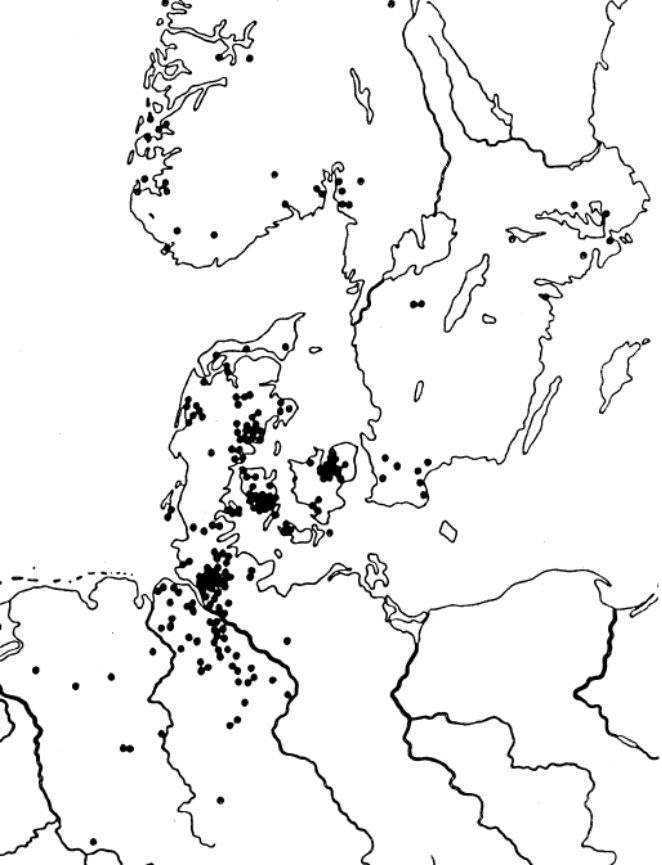
The mapping (see
figure 18) shows that these names are mainly found in northern Germany, the Netherlands, Belgium and England. Apparently the settlers immigrated to England via the Channel.
Figure 18. Riede, ride, rithe, riet, rið in geographical names (Source: Udolph 1994: 393, map 34).
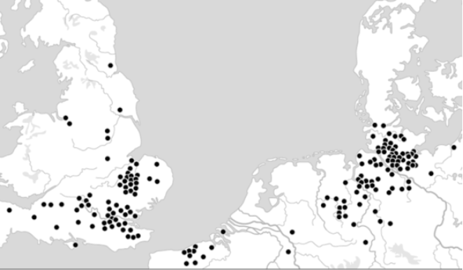
e. An old word that primarily connects Northern Germany and England is German Hude. A German speaker only knows this from place names, especially from Buxtehude, Fischerhude, Harvestehude and the Steinhuder Meer. However, the meaning of this word remains unknown to a modern speaker. In Northern Germany, Hude is mainly found in the names of settlements that are located on bodies of water; in Middle Low German it is still attested as hûde “wood storage area, stacking area on a water connection, ferry station”. It is also unknown in modern English, but it is still attested in Old English: hyð "place that receives the ship when landing, a suitable low bank, a small harbor".
The distribution of place names is interesting. From Germany were collected, among others: Altenhude; Aschenhude; Billerhude; Dockenhuden, 1184 Dockenhuthe; Dodenhuden; 1346 Eckhude; Fischerhude, 1124 Widagheshude; Flemhude; Frauenhude; Grönhude; Hamhude; Harwestehude; Heemhude; Huden near Meppen, 1037 Huthun in the document Hlareshuthun; Hodenhagen, 1168 (18th century copy) de Hode and others; Hude (common), also with umlaut Hüde; Huden, around 920 Huthun; Hudow; Hudemühlen; Kayhude; Neddernhude, Obernhude; Pahlhude; Ritterhude; Stapelhude, 1258 in loco qui dicitur Stapelhuthe; Steinhude on the Steinhuder Meer, 2nd half 14th century To the Stenhude; Tesperhude; Winterhude.
The Netherlands also has place names: Coude Hide in Zealand; Coxyde, 1270 de Coxhyde; Coxyde (Koksijde); Hude, 1405 Hude; Hude driesch; Huderstrate; 1359 le Hyde, near Dunkirk; Nieuwe Yde near Nieuwpoort/Oostduinkerke, 1277 Nova Hida; Raversijde, 1401 Wilravens hyde; Lombartsijde, 1408 Lombaerds yde; Yde, 1331 in the Hide.
The place names in England are important and old: Aldreth, 1169-72 Alreheð(a), -huða; Bablock Hythe; Bleadney, 712 (copy 14th century) ad portam quae dicitur Bledenithe; Bolney, 1086 Bollehede; Bulverhythe; Chelsea, 785 Cealchyþ, Celchyð, 801 Caelichyth; 1275 Cholleshethe; Clayhithe, 1268 Clayheth; Covehithe; Creeksea, 1086 Criccheseia; Downham Hythe, 1251 Dunham hythe; Earith, 1244 Herheth; Erith, 695 Earhyð; fish hythe; Frecinghyte; Glanty, 675 (copy 13th century) Glenthuþe; Greenhithe; Heath (multiple times); Hidden, 984 (copy around 1240) (innan) Hydene; Hithe Bridge; Hive, 959 (copy around 1200) Hyðe; Hive, 1306 atte hethe; Horsith, 1249 Horsyth(e); Hyde, 1333 atte Hithe; Horseway, 1238 Hors(e)hythe; Hullasey, 1086 Hunlafesed; Huyton, 1086 Hitune; Hythe (Surrey), 675 (copy 13th century) huþe; Hythe (Cambridge), 1221 Hethelod; Hythe (Kent), 1052 (on) Hyþe; Hythe (Hampshire), 1248 (la) Huthe; Knaith, 1086 Cheneide, < cnêohȳþ; Lakenheath, ca. 945 æt Lacingahið; Lambeth, 1041 Lambhyð; Maidenhead, 1202 Maideheg; Prattshide, c.1250 Pratteshithe; Rackheath, 1086 Racheitha; Rotherhithe, around 1105 Rederheia; Sawtry, 974 Saltreiam; Small Hythe, 13th century Smalide; Stepney, around 1000 Stybbanhyþe; Swavesey around 1080 Suauesheda; Welshithe, supposedly 675 Weales húðe.
Figure 19. German hude, English hyð etc. in place names (Source: Udolph 1994: 472, map 44).
The distribution of the names (see
figure 19) clearly shows that there is no evidence that settlers came to England from Schleswig-Holstein or Jutland. Rather, the place names in Flanders must be taken into account, which apparently form the bridge between the German and English names.
Hermann Jellinghaus had already recognized a hundred years ago that the Hude names were “strong evidence of the origin of the tribe of the southern English population from the Low German plain.”
The distribution maps within Germania, as noted above, also show clear connections to the north. In the past, these were almost always interpreted as expansions of Germanic tribes from their northern European homeland towards the south. However, it can be clearly shown that an original homeland in continental Germanic can be assumed (for more details see Udolph
| [70] | Udolph, J. (1994): Namenkundliche Studien zum Germanenproblem, Berlin - New York. |
[70]
(S. 830-918).
f. A study by K. Bischoff
| [9] | Bischoff, K. (1975): Germ. haugaz 'Hügel, Grabhügel' im Deutschen. Eine Flurnamenstudie. Mainz. |
[9]
, see also Udolph
| [70] | Udolph, J. (1994): Namenkundliche Studien zum Germanenproblem, Berlin - New York. |
[70]
(S. 859-863) gives us more precise knowledge about the spread of the word
*haugaz in Germanic, which is attested, among other things, in anord.
haugr 'hill, burial mound', note also in similar meanings Icelandic
haugur, Faroese
heyggjur, heygur, Norwegian
haug, Swedish
hög, Old Danish høgh, Danish
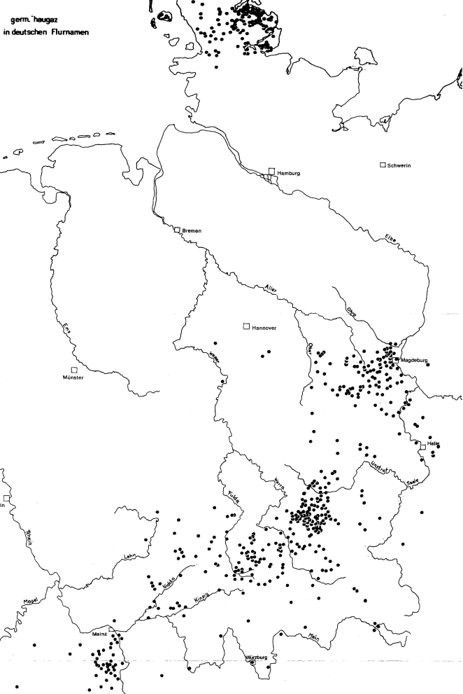
høi. But it can also be found in place names in Germany; K. Bischoff
| [9] | Bischoff, K. (1975): Germ. haugaz 'Hügel, Grabhügel' im Deutschen. Eine Flurnamenstudie. Mainz. |
[9]
(Supplement) provides a distribution map (see
figure 20).
Figure 20. Distribution of hauga- in geographical names (from Bischoff 1975: supplement).
g. Klint is a very similar word, a word that is primarily used as an appellative in the north. It is attested: Danish klint 'steep sea shore', Swedish klint 'top of a hill', assimilated secondary form in Swedish dial. klett, Norwegian dial. klett ‘mountain top, steep sea shore’, already Old Norse klettr 'free-standing cliff', ablaut form in Norwegian dial. klant ‘cliff edge, mountain peak’ and Danish klunt ‘lump, lump, blocky person’.
But it is also found in the stock of names, the “graveyard of words” not to a small extent in the continental Germanic area, as
figure 21 shows. The scatter is very similar to that of
hauga-. Figure 21. Distribution of klint in geographical names (Source: Udolph 1994: 868-888, map 68).
h. The often discussed and quoted basic word -leben (North Germanic -lev also belongs here), which is attested in around 200 place names, e.g. in Uhrsleben, Erxleben, Eilsleben, Meilersleben; Aschersleben, Oschersleben, Eisleben, Barleben, Roßleben, and in Denmark and southern Sweden as Bindslev, Jerslev, Roslev, Falslev, Tinglev and others.
The basis is Gothic laiba “remnant”, Old High German leiba, Old Saxon lëva “remainder, inheritance, estate”, Old Frisian lâva “legacy, inheritance, inheritance law”, Old English. lâf “legacy, legacy”, Old North leif “remnant”, Old Danish kununglef “crown estate”. In the first part there is always a personal name in the genitive singular.
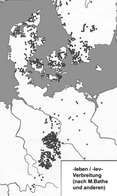
The unusual spread of names (see
figure 22) has often been discussed, although the large and most comprehensive book on these names received almost no attention [Bathe
| [6] | M. Bathe [undated], Die Ortsnamen auf -leben, manuscript [Berlin]. |
[6]
. If this is taken into account, there is more evidence for a south-north migration than the opposite direction, cf. Udolph
| [70] | Udolph, J. (1994): Namenkundliche Studien zum Germanenproblem, Berlin - New York. |
[70]
(S. 497-513).
Figure 22. Distribution of place names with -leben/-lev (according to M. Bathe and others).
i. The unusual spread of names (see
figure 22) has often been discussed, but the largest and most comprehensive book on these names is almost was not taken into account (Bathe
| [6] | M. Bathe [undated], Die Ortsnamen auf -leben, manuscript [Berlin]. |
[6]
). If you take this into account, there is more to be said for it a south-north migration as the opposite direction, cf. Udolph
| [70] | Udolph, J. (1994): Namenkundliche Studien zum Germanenproblem, Berlin - New York. |
[70]
(S. 497-513).
j. And a final example of the name connections between the continent and the Scandinavian north: assumed in North German place names one Middle Low German
Wedel, Old Saxon.
widil ‘ford’, which is related to Old Norse
vadhell, vadhall, vadhill ‘shallow place in the fjord for wading across’, Norwegian
val, vaul ‘shallow fjord spot’, in place names also
Voil, Veel, Danish
vedel, vejl (16th century), Danish place names
Veile, Veilby, Veielgaard, Veilö, Faareveile, the meaning in Denmark is primarily 'passage through boggy terrain' (For distribution see
figure 23).
The connections with the Scandinavian north briefly outlined here can also be found in a special feature, which lies in the fact that exclusively appellatives attested in Nordic also in names of continental Germanic area can be found (detailed and interpreted in Udolph
| [77] | Udolph, J.. (2000c): “Nordisches in niedersächsischen Ortsnamenˮ. In: Raum, Zeit, Medium – Sprache und ihre Determinanten. Festschrift f. H. Ramge, 59-79. |
| [79] | Udolph, J. (2004b): “Nordisches in deutschen Ortsnamenˮ. In: Namenwelten. Orts- und Personennamen in historischer Sicht. Berlin - New York, 359-371. |
| [80] | Udolph, J. (2004c): Alemannien und der Norden aus der Sicht der Ortsnamenforschung. In: Alemannien und der Norden (1) (S. 29-56). |
| [86] | Udolph, J. (2011b): “Skandinavische Wörter in deutschen Ortsnamenˮ. In: Probleme der Rekonstruktion untergegangener Wörter aus alten Eigennamen. Eigennamen. Uppsala, 141-158. |
[77, 79, 80, 86]
. There are now more than three dozen of these cases known, including the names
Braunlage, Dorstadt/Dorestad, Kösen/Coesfeld, Ohrum, Oerie, Rhön
| [4] | Ascher, D. (2020): Die Ortsnamen des Landkreises Fulda, Freiburg. |
[4]
(S. 203ff.) Scheuen, Sch
eie.They can only come from an ancient, common or proto-Germanic period and show that the underlying appellatives of this ancient layer must have listened.
If you map these place names (see
figure 24), you can see that there is a center these place names that can only be explained with the help of Scandinavian words there is: it is eastern Lower Saxony with the adjacent areas in Saxony-Anhalt, Thuringia and Northern Hesse. A very similar picture emerges, if you consider appellatives that are only available in Scandinavia and the Alemannic area can be found (On the topic cf. Kolb
| [30] | Kolb, E. (1957): Alemannisch-nordgermanisches Wortgut. Frauenfeld. |
[30]
and und the anthology Alemannien und der Norden
| [1] | Alemannien und der Norden. Berlin - New York 2004. |
[1]
), look for place names on the continent (see
figure 24).
Figure 24. Scandinavian words in German place names (Source: Udolph 1980).
It is known that an important change in the formation of nouns took place in the Germanic language history: while today mainly compounds are used, cf. German Hand-tuch, Auto-reifen, Haus-wand, English main door, forrest path, car tyre, Norwegian hoved dør, skov vej, bildæk, new words were formed in the early Germanic period, especially with suffixes, i.e. as a derivation: *gab-lo- “fork”, *ham-iþja- “shirt”. When searching for ancient Germanic place names, the suffix formations are particularly important. For reasons of space, just a few examples are selected here.
1. -s-formations
In ancient times, Germanic partly inherited
-s-formations in its appellative stock, but partly also formed them anew. One should remember, for example, old hereditary words such as Gothic
aiz, bariz-eins, rimis as well as some new formations (which can also be based on old
s-stems) such as Gothic
aqizi, jukuzi, Old High German
chuburra. Further developments of the suffix
-sa-/-sō- are also characteristic of Germanic, such as formations with a middle vowel such as ahd.
bilisa, elira, felis(a). H. Krahe/W. Meid
| [33] | Krahe, H.; Meid, W. (1967): Germanische Sprachwissenschaft. Bd. 3: Wortbildungslehre. Berlin. |
[33]
(S. 137) also provide a brief compilation of “Old Germanic names with s-suffix”. In addition to personal names such as
Gabso, Hariso, Aliso, Thoriso, river names such as
Ems and
Effze are also mentioned, which are rightly linked to non-Germanic material. R. Möller
| [41] | Möller, R. (2000): Niedersächsische Siedlungsnamen und Flurnamen mit k-Suffix und s-Suffix in Zeugnissen vor dem Jahre 1200. Hei¬delberg. |
[41]
and J. Udolph
| [70] | Udolph, J. (1994): Namenkundliche Studien zum Germanenproblem, Berlin - New York. |
[70]
examined and compiled corresponding formations in the name inventory. I am ignoring the fact that
-s-formations can also be found in pre-individual water names of the Old European hydronymy (briefly discussed in Udolph
| [70] | Udolph, J. (1994): Namenkundliche Studien zum Germanenproblem, Berlin - New York. |
[70]
(S. 199-201).
These include, among others: a desert town Blekisi, 826-876 in Blekisi; desert Degese, 1196 Degese; Devese; Gebesee near Erfurt, 802-815 Gebise; Heerse < Herisi; Hünxe, 1092 Hungese; name of a desert Ilse near Boffzen (near Höxter), 1031 Ilisa; Ilvese, 1096 Hilvise; Klings near Bad Salzungen, 869 Clingison; Laisa on the Eder River, 8th century Lehesi, Lihesi; Lens near Bodenwerder, 1st half 9th century Linesi; Meensen near Göttingen, 990 Manisi; Resse near Recklinghausen, 10th century Redese; Reese near Stolzenau, 11th century Raedese, Schlipps near Freising, between 851 and 1130 Slipfes, Slipphes, Sliphes, Schlipfs; Seelze near Hannover, 1160 Selessen, 1187 Selesse; field name Sötz, swamp forest near Goslar, noted early as Sotisse; Vielshof near Salzkotten, noted ca. 1130 (Vita Meinwerci) Vilisi.
The mapping (
figure 25) shows a picture that you already know from other distribution maps: The core areas are southern Lower Saxony, western Saxony-Anhalt, northern and western Thuringia, northern Hesse and Westphalia.
Figure 25. -s-suffixes in geographical names of Central Europe (Source: Udolph 1994: 199-218, with map 25).
2. -st-formations
There are numerous formations with an -st-suffix, especially in the Baltic languagess. among others, the following stand out: in Latvia: Līlaste, Ļubasts, Ļubeşta, Mùrmasta; from the rest of the Baltics: Ab-istà, Akn-ystà, Arv-ỹstas, Avinúostas, Debr-estis, Grab-uostà, Iẽž-esta, Lam-īstas, Laukystà, Lokystà, Malkėsta, Pekl-ystà, Savìstas, Taurósta, Uol-astà, Varn-úostas, Ým-asta, from Austria Aist < *Agist(a), from France Autisse < *Altīssa < *Altīstā, from Dalmatia Bigeste, Ladesta, Trieste, Palaeste, Segest-(ica), Penestae, from Veneto Este < Ateste.
In addition to the two centers that stand out here, namely the Baltic States and the areas around the Adriatic, there is another area that has a significant share in the suffix in the name: Central and Northern Europe. A more precise distribution is shown on
figure 26, which includes, among other things:
866 Alesta, place-name near Charleroi; Alst near Warendorf, 12th century Alest; Aalst, place-name in Flanders, 866 Alost; Aalst, place-name near Hasselt, 1107 Alost, Alste; Aalst in Gelderland, around 850 Halosta; Alst near Leer, 12th century Alst; river name Apfelstädt in Thuringia, also place-name, 775 Aplast; Arzbach near Gotha, 1049 Arestbach; Beverst near Tongern, 1314 Beverst; place-name, mentioned in the Vita Meinwerci (ca. 1130): Bilisti; River name (inflow to the Rhine) Burdist, 755 Burdist; *Agist- possibly in Eekst near Aces; Ehrsten near Kassel, earlier documented as Heristi, Herste; Elst near Nijmegen, 726 Helistê; Ennest near Olpe, 1175 Ennest; Ergste near Schwerte, 1096 Argeste; Evelste near Pattensen, 1246 in Evelste; Exten near Rinteln, 896 Achriste; place-name Forst near Holzminden, < *Farista; Haste near Os-nabrück, 1146 Harst; Harste near Göttingen 1141 Herste, Harste; field name Idesten or Itesten near Emden; river name Innerste, old Indrista; desert place 1106 Lammeste near Hanover; place name Landas near Lille, old Landast; Leveste near Hannover, 1229 de Leueste; place name Pretitz near Zingst, 9th century Bridasti; place name Ranst near Antwerp, 1140 Ramst, 1148 Ranst; Riemst near Tongern, 1066 Reijmost; Rumst near Antwerp, 1157 Rumeste; Selsten near Geilenkirchen, can bei reconstructed as *Salist; Thüste near Hamelin, 1022 (forgery) Tiuguste, Thiuguste; Villigst near Ergste, 1170 Vilgeste; Zingst near Nebra, 1203 Cindest.
Numerous other parallels have now been added to this collection from 1994, especially through the comprehensive study of the place names in Lower Saxony and Westphalia.
Figure 26. -st-suffixes in geographical names of Central Europe.
● Water names; ○ Place or field names (Source: Udolph 1994: 218-243 with map 26).
It is important to note that place names with an -st-suffix in their presuffixal element show a wide variety of variants. So, -est- can be demonstrated with some certainty in Al-est, Ar-est, Id-est, Lam-este, Tind-est; -ast apparently appears in Ap-l-ast, Har-ast, Land-ast and Bredh-asti; Very common is -ist-: Bil-is, Burd-ist, El- ist, Am-ist, An(d?)-ist, Arg-ist, Agr-ist, Far-ist-ina, Har-ista, Lev-ista, Ram-ista, Sal-ist, Far-ist, Felg-ist.
The diversity of the suffix is completely consistent with the observations in the appellative stock. This can be easily demonstrated, especially in Germanic and Baltic. For most of the place names compiled, the Germanic conditions can be compared; this applies, for example, to the following place names, which can be explained quite convincingly with the help of Germanic word material: Awist, Beverst, Eext, Ehrsten, Idesten/Itzstedt, Landast, Riemst, Selsten/Zelst/Zeelst, Thüste, Villigst, Zingst.
While names with the -st-suffix can also be found in non-Germanic settlement areas, things are different with the following element.
3. -str-suffix
This suffix can bei found only in the Germanic languages, for example in the appellative area in Gothic
awistr, Norwegian
naustr, German
Laster < *lah-stra-, Polster < *bulh-stra-, Old Norse
mostr < *muh-stra-, Old English
helustr, heoloster, Gothic
hulistr ‘cover’, Old English
gilister, geoloster ‘ulcer’. And the names created with it are also limited to the (original) Germanic settlement area (
figure 27). According to a list from Udolph
| [70] | Udolph, J. (1994): Namenkundliche Studien zum Germanenproblem, Berlin - New York. |
[70]
(S. 243-258), this includes, for example,
Alster, Elster, Alstern, Alsterån; river name
Ballestre in England, 940
Ballestran; river name
Beemster near Alkmaar, 1083
Bamestra; Beuster, tributary of the Innerste, 1305
Bostere, 1308
Botestere; Emster near Brandenburg, old
Demster or
Emster; Norwegian river name
Imstr; Falster; Finster near Limburg, before 893
Veneter, Wene-stre, Uenestre; Fløstr, Scandinavian island;
Gelster, tributary of the Werra, 1246
between Gelstram; Norwegian river names
Jølstra, *Jøstra; Kelsterbach, place and field name near Groß Gerau, 830-850
De Gelsterbach; river name Lister (Westerwald), 1532
in der Lyster; English river name
Medestre, 940
(on) Medestran; Fjord name
Ørstr; Seester(au), old name of Krückau, tributary to the Elbe, 1141
iuxta fluuium Ciestere, with place name
Seester, Seesterau; Susteren, Ortsname in the Netherlands, 1277
Rususteren, < river name
Suster, 714
Svestra; Ulster, river name in the Rhön, 819
Ulstra; Swedish sea name
Vänstern, Norwegian river names
Vinstr, Vinstra, English river name
Winster, 1170-84 (copy)
Winster; Wilster, → Medem,
Wilster Au (Wilsterau) → Stör;
Zester, missing place name (Altes Land), 1197 i
uxta Szasteram, also missing place name
Zesterfleth, 1221
Sestersvlete.Almost all of these names - more have since been added - can be explained from Germanic word material. But there are exceptions, e.g. Alster, Elster and Wilster. Here the individual language, Germanic suffix is based on a pre-Germanic basis *el-/*ol- or *wil-, which speaks for a certain continuity from Indo-European to Germanic settlement in these geographical areas.
Figure 27. -str-suffixes in geographical names of Central, Northern Europe and England.
● Water names; ○ Place or field names (Source: Udolph 1994: 256-272 with map 27).
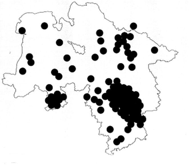
4. The suffix -ithi
This suffix has already been discussed several times (Udolph 1994: 258-288; Möller 1992; Casemir 2003: 438-446). It is an ancient word formation element that has left clear traces, especially in the formation of names. It is no longer productive today and is only known to us in a few words from the older Germanic languages: Gothic avithi “herd of sheep”, Anglo-Saxon gesylhbe “yoke of oxen”, Old English winterfylled “october”, Old High German winithi “pastureland”, juhhidi “Team” and a few others.
While it is hardly recognizable in appellative terms, which suggests that it is relatively old, it is well known in northern and central German place names. There are around 200 names here, including quite well-known ones. Here is just a small selection: Birgte, 1088 Bergithi; Bleckede on the Elbe; Bünde, 853 (forgery) Buginithi; Dingden near Bocholt, 1163 Tingethe, to Old High German thing, ding “general people’s assembly”; Döhren, district of Hannover, around 990 Thurnithi; Essen, 9th century Astnide; Geesthacht, 1216 in Hachede; Gimbte, 1088 Gimmethe; Grohnde, (1237-47) in Gronde; Helle near Wiedenbrück, end of 12th century Helethe; Huckarde, district of Dortmund, 947 Hucrithi; Hüsede, 12th century Husithi; Lengede, 1151 Lencethe; Mengede, district of Dortmund, 10th century Megnithi, Mengide; Meschede, 913 Meschede, 1015-25 Meshethi; Sarstedt, (1046-1056) Scersteti, Scerstete, 1196 Scardethe; Sehnde, 1147 Senethe; Sömmerda, 876 Sumiridi item Sumiridi.
West Germanic settlers who translated to England from the 5th century onwards took the element with them and, as
figure 28 clearly shows, created a few place names on the island before the suffix became unproductive and disappeared from the language. These place names include: in Kent e.g.
The Brent, Brent Lane, late 14th century
Bremthe; Desert name 13th century
Bremthe; Desert name 1286
Bremthe; Brent Cottages, 1359
Brencche; 1206
La Brenithe (for
Bremthe?); Further
Frant, 956, 961
(æt) Fyrnþan, 1177
Fernet, 1296
Fernthe, 1332
Frenthe; Rowfant (Sussex), 1574
Rowfraunte; Feltham (Somerset), 882
Fælet-, Fylethamm; Desert name
Helthe in Kent, 1242-43
Helcthe, Helgthe, 1252-54
de Holgthe, 1254
de Heilkthe, 1270
de Helgthe; Desert name
Horsyth in Dorset, 13th century
horside, 1249, 1256
Horsyth(e), 1256
Horseth, 1327, 1331, 1463
Horsith(e), 1331,1338
Horsyth(e); Tilt, ON. in Kent and in Surrey, 1328
la Tilthe; Tiltwood in Sussex, 1327
ate Tilthe, also
Backtilt Wood, 1254
de Beketilthe, 1278
de Beketilthe etc. as well as
Baretilt, 1285
Bertilth, 1313
de Bertilthe, in Kent.
Figure 28. Place names with the suffix -ithi (Source: Udolph 1994, map 28).
The distribution of names on the continent shows very clearly where the West Germanic settlers came from: the place names in -ithi mark the old settlement areas very precisely. They essentially correspond to the distribution of the Germanic basic words and suffixes discussed in this article, although of course each mapping has its own structure and no two are exactly the same. But a number of important consequences can be drawn for ancient Germanic settlement areas.
Among the dense network of individual language Germanic place and water names, pre-Germanic hydronyms can be recognized in large numbers in northern and central Germany, for example in the study by Kettner
| [29] | Kettner, B.-U. (1972): Flußnamen im Stromgebiet der oberen und mittleren Leine, Rinteln. |
[29]
; now also compare Greule
| [22] | Greule, A. (2014): Deutsches Gewässernamenbuch, Berlin/Boston. |
[22]
; These can also be determined through the Hydronymia Germaniae series by referring to the relevant literature.
If one now attempts to map the distribution of Old Germanic names, in my opinion the crucial point is that it must be possible to identify both the types of names that extend to the west (e.g. formations with the suffixes
-ithi, -st- and with the Appellatives
hor, mar-, Riede, Hude, (h)lar etc.) as well as for the suffixes and words connecting the continental Germanic area with Scandinavia to find a common geographical basis. There is an attempt describe this
| [70] | Udolph, J. (1994): Namenkundliche Studien zum Germanenproblem, Berlin - New York. |
[70]
(S. 925ff.) and a mapping is encluded here which roughly outlines the area to bei taken into account based on the geographical names as the home and expansion area of Old Germanic speakers, see
figure 29.
Figure 29. Based on ancient Germanic place name types, it is assumed to be the oldest settlement area of ancient Germanic settlers.
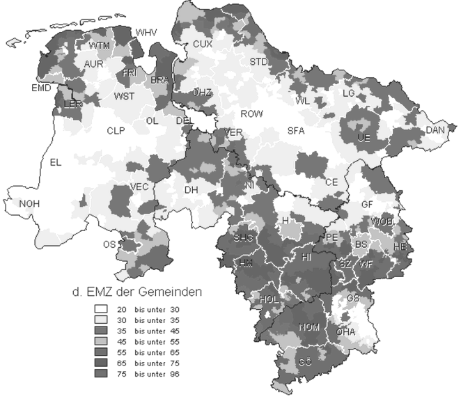
It is clear that this mapping invites criticism. But I would like to emphasize again that the water and place names certainly speak for this area. And there is - as already mentioned above in the discussion about Slavic - another important argument that is used again and again by historians and agricultural scientists: what is meant is the quality of the soil, the types of soil. Mapping, for example, of the soil types in Lower Saxony, shows an almost complete coverage of the best soils with the ancient Germanic names mentioned above and their distribution. It´s a map of Lower Saxony that shows the country's yield metrics - the best soils appear in dark colors (
figure 30).
Figure 30. Yield metrics for soils in Lower Saxony (Source: http://www.nls.niedersachsen.de/Tabellen/Landwirtschaft/internetseite2002/hochschulen.pdf).
This is explained in the source from which the mapping was taken: “Good soils only predominate on the coast and south of the Mittelland Canal. In the sand sea of Geest and Heide, a few 'fat eyes' swim with good, loamy soils, like a few fat eyes on a barren soup (Uelzen; Lüchow; Weser-, Leine-, Allertal; Artland; Hoya-Syke-Goldenstedt)".
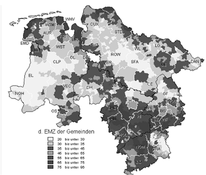
The correspondence between soil quality and ancient place names is made particularly clear by the following comparative mapping, which shows both the distribution of the
-ithi-place names in Lower Saxony and the yield metrics of the soils in Lower Saxony (
figures 31, 32).
We can therefore draw the same conclusions as in the discussion about the Slavic homeland: it is clear that the distribution of the best soils in central and northern Germany corresponds to the old Germanic water and place names. It is known that the Börden (Soester Börde, Calenberger Lössbörde, Hildesheimer Börde, Magdeburger Börde) in the northern German old moraine area on the edge of the low mountain ranges have black earth soils that are among the best soils in Germany. Every farmer knows what it means when people talk about 80 or more soil points. As stated in the discussion of Slavic above, good soil generally leads to good and better harvests than poorer soil. The result is lower child mortality and higher life expectancy. The population is increasing, which in turn leads to some overpopulation, migration and spread of the language of the region's speakers. Sensational finds such as those in the Lichtenstein Cave near Osterode and the knowledge that the people who lived there 3,000 years ago still have descendants in this area today (proven by DNA analyses; taken up and treated from an onomastic perspective and supplemented by Udolph
| [84] | Udolph, Jürgen (2009): “Lichtensteinhöhle, Siedlungskontinuität und das Zeugnis der Familien-, Orts- und Gewässernamenˮ. In: Historia archaeologica. Festschrift f. Heiko Steuer, Berlin - New York, 85-105. |
[84]
, show that that settlement continuity in the Harz region can be assumed with certainty.
c. The Celtic
From summaries of the state of Celtic place name studies it can be seen that there is agreement that island Celtic arose through relocation from the continent. The origins can therefore be found in central or western Europe. For mainland Celtic water names, the studies by Billy
| [8] | Billy, P.-H. (1993): Thesaurus linguae Gallicae. Hildesheim. |
[8]
, Delamarre
| [16] | Delamarre, X. (2003): Dictionnaire de la langue gauloise. 2. Auflage. Paris. |
[16]
, Falileyev
| [18] | Falileyev, A. (2006/7): Dictionary of Continental Celtic Place-Names. A Celtic Companion to the Barrington Atlas of the Greek and Roman World, Aberystwyth 2010. |
[18]
, Matasović
| [38] | Matasović, R. (2009): Etymological Dictionary of Proto-Celtic, Leiden. |
[38]
and Sims-Williams
| [58] | Sims-Williams, P.(2006): Ancient Celtic Place-Names in Europe and Asia Minor. Oxford. |
[58]
are of particular value. The following map is based primarily on archaeological research, but also corresponds to a large extent to the assumptions of linguistics.
Figure 33. Migrations, land seizures and influence of the Celts up tot he 1st century BC (Source: http://www.timediver.de/Keltenwelt_am_Glauberg.html). laps?
The decisive step was taken by P. Busse
| [11] | Busse, P. (2007): “Hydronymie und Urheimat: Ein neuer Ansatz zur Lokalisierung der Urheimat der Kelten?ˮ. In: Kelten-Einfälle an der Donau. Akten des 4. Symposiums Deutschsprachiger Keltologinnen und Keltologen vom 17.-21. Juli 2005 in Linz. Wien, 89-98. |
[11]
in a small contribution to a Celtic conference, although these ideas are only the first starting points for a larger project. He rightly emphasizes that the processing of the hydronyms is absolutely necessary, as this “has not yet been achieved with regard to the question of Celtic-speaking settlement” (Busse
| [11] | Busse, P. (2007): “Hydronymie und Urheimat: Ein neuer Ansatz zur Lokalisierung der Urheimat der Kelten?ˮ. In: Kelten-Einfälle an der Donau. Akten des 4. Symposiums Deutschsprachiger Keltologinnen und Keltologen vom 17.-21. Juli 2005 in Linz. Wien, 89-98. |
[11]
: 89), in contrast to studies of Indo-European, Slavic and Germanic water names In Celtic, almost no studies were undertaken in this area. In his opinion, almost all researchers avoid this topic.
Busse
| [11] | Busse, P. (2007): “Hydronymie und Urheimat: Ein neuer Ansatz zur Lokalisierung der Urheimat der Kelten?ˮ. In: Kelten-Einfälle an der Donau. Akten des 4. Symposiums Deutschsprachiger Keltologinnen und Keltologen vom 17.-21. Juli 2005 in Linz. Wien, 89-98. |
[11]
rightly asks whether archaeological arguments can or should play a role in the question of the “Celticity” of settlers. He names S. James
| [28] | James, S. (1999): The Atlantic Celts, London. |
[28]
and J. Collis
| [15] | Collis, J. (2003): Celts - Origins, Myths and Inventions, London. |
[15]
as the main representatives of “Celto skepticism”, “the latter of which provides serious objections to the identification of archaeological evidence and ethnic classification”. This corresponds to a large extent with modern research in Germany, with reference to Brather
| [10] | Brather, S. (2004): Ethnische Interpretationen in der frühgeschichtlichen Archäologe, Berlin. |
[10]
in particular.
P. Busse
| [11] | Busse, P. (2007): “Hydronymie und Urheimat: Ein neuer Ansatz zur Lokalisierung der Urheimat der Kelten?ˮ. In: Kelten-Einfälle an der Donau. Akten des 4. Symposiums Deutschsprachiger Keltologinnen und Keltologen vom 17.-21. Juli 2005 in Linz. Wien, 89-98. |
[11]
draws the only sensible conclusion from this: If you look for Celts from a linguistic point of view, then this can only be done with linguistic arguments. But if you do that, then - and this is absolutely essential - you not only have to include the geographical names, but you also have to give them a very high priority. Among these, the names of rivers and seas are particularly important.
In his opinion, something that has already been attempted using Slavic and Germanic has become important for the question of the oldest places of residence of Celtic speakers: since the development of an Indo-European language family from an Indo-European pre-individual dialect area was a long process - man must certainly reckon with centuries - so not only water names from a single language, such as Celtic, Baltic, Germanic, but also Indo-European pre-single language relics can be expected in this area. The development must be reflected in the hydronyms, or, in other words, an area in which there are only individual language names, for example only Celtic names, cannot be the area of the original Celtic homeland.
Busse's project, which he only offers in outline, "intends to use and bundle the results of previous studies and projects on the subject of 'Celticity'... to find an answer to the question of the extent to which hydronymy provides a meaningful picture of early settlement history of Celtic-speaking population groups” (Busse
| [11] | Busse, P. (2007): “Hydronymie und Urheimat: Ein neuer Ansatz zur Lokalisierung der Urheimat der Kelten?ˮ. In: Kelten-Einfälle an der Donau. Akten des 4. Symposiums Deutschsprachiger Keltologinnen und Keltologen vom 17.-21. Juli 2005 in Linz. Wien, 89-98. |
[11]
: 91f.). Following H. Krahe and completely correctly, it is primarily about the water names, which are based on words for “water, river, flow” etc. Taking into account studies from the Germanic, Baltic and Slavic areas, he develops the following key questions:
1) Can an area of “Celtic hydronymy” be identified that can be considered the nucleus of Celtic expansion, i.e. the original homeland?
2) To what extent does this nucleus coincide with the expansion of the Hallstatt or La Tène culture?
In order to find answers to this, he deals, on the one hand, with water names that are in Celtic territory but are of pre-Celtic origin, and on the other hand with Celtic names. Included are, among others, Ainos, Aenus, Dubis fl./Doubs, Douglas and relatives, Devy/Devon, Devoke Water, Old Irish dobur with French Douvre (1128 Dobra), Douvres (approx. 380 Dubris), Verdouble (AD 79 Verno-dubrum) etc.; Spanish Dobra etc., German Tauber, English Dover; the clan around Glanis, Glanum, Glanon, Glan, Glene, Glane; borm-/borw-/borb- < *bher- “to rise, swell, ferment, boil” in Borbro (Bourbre), Borvo(n) “source god”, Formio, in France Bormane (Ain), Bourbonne (Aube), La Bourbre (Isere) and many others; brig- < *bh3gh- to *bheregh- “high, lofty”, perhaps meaning “upper reaches” in Brigia (Braye = Loir), Brigulos (Saône → Rhône) and many others; -esk-/isk- < *peisk-, medium Irish esc “water” with Esca/Escia/Hisca (Isch → Saar) and others; fruta- < *s(“)rutu-, cf. Kymrian fjF-wd, Irish sruth “fall stream”, in Frudis, river in Belgium and others.
In the conclusion, the results are summarized using a distribution map: “As a first preliminary result, taking into account the map material, the following can be stated: Celtic hydronymy is distributed over an area that is located on the northern edge of the Alps along the Danube, the Upper and the middle reaches of the Rhine and the Rhône, including the tributaries. The starting area of the Hallstatt culture is not the same as this area, although the most important West Hallstatt and early La Tène finds can be found in this area”
| [11] | Busse, P. (2007): “Hydronymie und Urheimat: Ein neuer Ansatz zur Lokalisierung der Urheimat der Kelten?ˮ. In: Kelten-Einfälle an der Donau. Akten des 4. Symposiums Deutschsprachiger Keltologinnen und Keltologen vom 17.-21. Juli 2005 in Linz. Wien, 89-98. |
[11]
(S. 97). It is only mentioned here in passing that the Polish Indo-Europeanist J. Rozwadowski (partly printed in Rozwadowski
| [46] | Rozwadowski J. (1948): Studia nad nazwami wód słowiańskich, Kraków. |
[46]
) in his research, which dates back to the first years of the 20th century. Going back, he found striking similarities between the names of water bodies in the Baltic and the Rhône region, such as
Visentia, Saane, Brenne, Divonne, Isara, Drome, Ivarus and others.
This has now been consolidated even further. Important parallels in names have been identified in France (Schmid
| [54] | Schmid, W. P. (1994): Linguisticae Scientiae Collectanea. Ausgewählte Schriften, Berlin - New York. |
[54]
) and in the Moselle area
| [53] | Schmid, W. P. (1988): “Zu einigen keltisch-baltischen Namenentsprechungenˮ. In: Studia Indogermanica et Slavica. Festgabe für Werner Thomas, München, 49-56. |
[53]
, and clear similarities between Old European water names in Poland and the Baltic States and the British Isles, northern and southern France have been shown Udolph
| [70] | Udolph, J. (1994): Namenkundliche Studien zum Germanenproblem, Berlin - New York. |
[70]
(S. 332ff.) that almost the entire Celtic settlement area (less certain: the Iberian Peninsula) contains a substrate of pre-individual Indo-European water names.
If one tries to weigh up the previous investigations into the names of waters in Europe and P. Busse's attempt at Celtic, then in my opinion the following common points can be identified:
1. The names of water bodies are the oldest evidence of human language in Europe. Their investigation is essential for questions of prehistory and early history.
2. In the area of the former Celtic settlement on the mainland (especially in northern Italy, France and parts of Switzerland) there is a lack of comprehensive studies of hydronymy.
3. Unfortunately, archaeological results can only be used to a limited extent to answer the question of the ethnic structure of early Europe [Brather 2004].
4. Since the water names are essentially derived from so-called “water words”, a comprehensive study of the geographical terminology of all Celtic languages is an urgent desideratum (this also applies to the area of Germanic languages, while it is exemplary in Slavic, even studies limited to the water names).
P. Busse has to enter in a mapping the names of waters that, in his opinion, are important for determining the oldest settlement areas of Celtic tribes.
Based on the investigation by P. Busse and based on corresponding research in the field of Germanic and Slavic, one can say: There is a lot to be said for the fact that the development of Celtic took place where a certain “thickening”. increased concentration of old European water names had already been seen. Of crucial importance is the existence of parallels in the Baltics and the neighboring regions, which J. Rozwadowski 1948
| [46] | Rozwadowski J. (1948): Studia nad nazwami wód słowiańskich, Kraków. |
[46]
already pointed out. A word that already played a role in questions about the homeland of the Germanic tribes also applies to the question of the ancient Celtic residences: Ex oriente lux [Cf. Udolph, Ex oriente lux, 2-mal]. Taking this into account, there is already a lot to be said for the area west of the Alps - and one can essentially follow P. Busse. Research in the countries formerly populated by Celts would do well to focus more intensively on the names of water bodies than before.
d. The Baltic from an onomastic point of view names
Linguists and name researchers repeatedly emphasize the continuity in the settlement history of the Baltic. Larger migration movements can hardly be recognized, but there is a process that shows a considerable reduction in the size of the former Baltic settlement area (W. P. Schmid offers a map based on the publications of M. Gimbutas, which needs to be corrected in detail (
figure 35).
Figure 35. Distribution of Baltic water names (Source: Schmid 1976: 15 after M. Gimbutas, The Balts, London 1963, S. 30f.).
Essentially, they are Slavic tribes that assimilated Baltic from the east, south and southwest, clearly visible in parts of northwestern Russia, Belarus and northeastern Poland. From a hydronymic point of view, a distribution map of water body names is interesting, which, in the opinion of J. Rozwadowski
| [46] | Rozwadowski J. (1948): Studia nad nazwami wód słowiańskich, Kraków. |
[46]
, can be described as “Slavic” (Map 36). However, these are by no means Slavic, but rather pre-individual, Indo-European water names. This is made clear by the headings of individual sections of his studies, such as “dreu- (Drwęca, Drawa...)”, “Isa”, “Isana”, “Isara”, “Oła i jej grupa: pierwiastek el-”, which are partly are almost identical to the much later investigations by H. Krahe and largely agree with Krahe's investigations and results. In Western Europe they remained completely unnoticed.
A map from a recent publication (
figure 37) shows something similar, as it shows a clear increase in pre-Slavic water names in the territories bordering the former Baltic settlement area in northeastern Poland, which are undoubtedly in the adjacent Baltic settlement areas continues.
Figure 37. Oldest water names in Poland according to Babik 2001.
In the meantime, it has also become clear that the water names considered Slavic by J. Rozwadowski
| [46] | Rozwadowski J. (1948): Studia nad nazwami wód słowiańskich, Kraków. |
[46]
have to be interpreted differently: a small part of them belongs to the Baltic substratum in Russia, Belarus, northern Ukraine and northern post-Poland, but a much larger part belongs to it the inventory of Old European hydronymy, which has been called this since H. Krahe
| [31] | Krahe, H. (1949-1950): “Alteuropäische Flußnamenˮ. In: Beiträge zur Namenforschung, 24-51. |
| [32] | Krahe, H. (1964): Unsere ältesten Flußnamen, Wiesbaden. |
[31, 32]
, a network of water names that is of pre-individual, Indo-European origin
| [29] | Kettner, B.-U. (1972): Flußnamen im Stromgebiet der oberen und mittleren Leine, Rinteln. |
| [54] | Schmid, W. P. (1994): Linguisticae Scientiae Collectanea. Ausgewählte Schriften, Berlin - New York. |
| [70] | Udolph, J. (1994): Namenkundliche Studien zum Germanenproblem, Berlin - New York. |
[29, 54, 70].
Figure 38. Baltic center in hydronymy (Source: Schmid 1994: 184f.).
And another important new insight was gained: within the Old European, pre-individual, Indo-European water names in Europe, Baltic has a special position, which W. P. Schmid
| [54] | Schmid, W. P. (1994): Linguisticae Scientiae Collectanea. Ausgewählte Schriften, Berlin - New York. |
[54]
(S. 175-192, 226-247) has worked out. Hydronymy in the former and current Baltic settlement area is characterized, on the one hand, by a large density of pre-individual language names, on the other hand, a stability and continuity in the formation of water names from the earliest Indo-European period to the individual language Baltic period can be seen and, finally, there is within the Old European Hydronymy only in the Baltics water names that have equivalents in many European regions. Examples include
Atesỹs, Ates  ,
, river names in Lithuania:
Etsch/Adige (recorded in antiquity as
Atesis, Athesis);
Eisa: Aisė; Limena:
Limenė in Lithuania,
Lac Léman, etc., mapping see
figure 38.
I was able to find something similar when examining the pre-Slavic names in Poland Udolph
| [69] | Udolph, J. (1990): Die Stellung der Gewässernamen Polens innerhalb der alteuropäischen Hydronymie, Heidelberg. |
[69]
(Summary: 331ff.). A mapping is based on this study, specifically on the compilations of name correspondences between Poland and various regions in Europe (e.g. British Isles, Western Europe, Northern Italy, etc., pp. 332-338), which is presented here (
figure 39).
Figure 39. Name correspondences between names of water bodies in Poland and European parallels (The material is in Udolph 1990: 332-338).
None of these are coincidences. As both older and more recent studies have made clear, the Baltic treasure trove of names shows correspondences in a ring of regions that extends from the British Isles, France, the Iberian Peninsula, Italy, Switzerland and Austria, the Balkans to Eastern Europe. Recently, these similarities have been increasingly identified, especially with Germanic, but there are also similarities between several Indo-European languages, especially between Baltic, Germanic and Slavic.
e. Overarching similarities in the names of two or more individual languages
As has become increasingly clear in recent years, the three Indo-European language groups Baltic, Germanic and Slavic are closely linked to one another in their names. On the one hand, these are Old European-Indo-European relics that stand out within Old European hydronymy through special features (morphology, vocabulary), and on the other hand, there are similarities between two of the three language branches. The material is presended in brief below and refer in particular to the literature mentioned in the individual sections.
1. Slavic-Germanic
I tried to outline the state of research in this area a few years ago
| [81] | Udolph, J. (2005a): “Slavisch-Baltisch-Germanische Übereinstimmungen in Toponymie und Hydronymieˮ. In: Reallexikon der Germanischen Altertumskunde, Bd. 29, Berlin - New York, 64-67. |
[81]
. From a linguistic point of view, similarities can also be demonstrated in the names; M. Vasmer has presented the first convincing attempts. Two periods can be distinguished in the relationship between Germanic and Slavic languages: 1.) In a more recent phase, since around the 2nd century AD, there has been more intensive contact, primarily due to the expansion of Germanic tribes were triggered in Eastern Central Europe. 2.) The phase of Germanic expansion was replaced around the 5th century by Slavic settlement movements, which took possession of an area originally populated by Germanic tribes.
Only in recent years has research on place names in the old Germanic settlement area identified traces of much older contact, dating back to the time when the Germanic and Slavic languages developed from an Indo-European dialect area. It's about the striking phenomenon that obviously Germanic names can only be etymologized with the help of Slavic words (the following examples are in Casemir 2003
| [13] | Casemir, K. (2003): Die Ortsnamen des Landkreises Wolfenbüttel und der Stadt Salzgitter (= NOB, Band 3), Bielefeld. |
[13]
, among others); these include
Empelde near Hannover, old
Amplithi, cf. Slavic
*ǫbl- in Polabian
wûmbal “fountain”, Bulgarian
vumbel, vubel, vubel’, vôbel, ubel “well or spring in a valley” etc.;
Hude “wood storage area, stacking area on a water connection, ferry station, harbor”, documented in numerous place names in northern Germany, probably North Sea German.
*hūth- and older
*hunþ- (for details and the geographical names derived from them, see above)
, the Slavic word
*kǫtъ in Russian
kut “end of a river arm that extends deep into the country” etc.;
Ilfeld, Ilten, Ilde, Ilsede go back to
*Il-feld, *Il-tun, *Il-ithi, *Il-is-ithi; the salty soil near Ilten and Ilsede is striking. A German interpretation is missing. An informal slavic word for “clay, mud” is ideal, e.g. Belarusian
il “thin dirt of organic origin in water, on the bottom of a waterhole, marshy, gray or white-colored land,” related to ancient Greek.
këýò “mud, feces”.
With this toponymic material one comes across an early period of linguistic contact, which proves that Germanic must have developed from an Indo-European dialect continuum in relative proximity not only to the Baltic, but also to the Slavic language area.
These observations also force us to consider the development of Germanic in the relationships between Germanic and Slavic (and Baltic) older and earlier relationships can be seen than with Celtic. This fact is still often ignored today. From an onomastic point of view there are no similarities between Germanic and Celtic.
2. Slavic-Baltic
The close relationships between Slavic and Baltic have been the subject of heated and controversial debates for more than a century (one of the last summaries of the discussions is provided by Dini
| [17] | Dini, P. U. (2005): “Slawisch-baltische Sprachbeziehungenˮ. In: Reallexikon der Germanischen Altertumskunde 29, 73-78. |
[17]
. However, little attention has been paid to the clear fact that in the area of Hydronymy and toponymy - unlike in the vocabulary - there were hardly any old similarities or contacts. As a clear center of Old European hydronymy, Baltic is integrated into the network of Indo-European water names in a completely different way than Slavic; the conditions are hardly comparable from an onomastic point of view Baltic has much closer ancient connections to Germanic than to Slavic.
3. Baltic-Germanic
The realization that there must have been particularly close relationships between these two branches of language is by no means new. As early as 1863, E. Förstemann
| [19] | Förstemann, E. (1863): Die deutschen Ortsnamen. Nordhausen. |
[19]
(S. 258, 331): “If we want to reconstruct our ancient linguistic and ethnic history, no language area is of greater importance to us than that of the so-called Baltic languages, which... are particularly close to Germanic stand” … “…because Lithuanian is in fact the closest genealogical relative of Germanic among all languages.” A summary evaluation including the research history can be found in Udolph (74; 81), and reference should also be made to more recent studies: Casemir/Udolph
| [14] | Casemir, K.; Udolph, J. (2006): “ Die Bedeutung des Baltischen für die niedersächsische Ortsnamenforschungˮ; In: Baltų onomastikos tyrimai (Gedenkschrift A. Vanagas), Vilnius, 114-136. |
[14]
; Schmid
| [53] | Schmid, W. P. (1988): “Zu einigen keltisch-baltischen Namenentsprechungenˮ. In: Studia Indogermanica et Slavica. Festgabe für Werner Thomas, München, 49-56. |
[53]
(S. 334-357); Udolph
| [74] | Udolph, J. (1999b): “Baltisches in Niedersachsen?ˮ. In: Florilegium Linguisticum. Festschrift f. W. P. Schmid zum 70. Geb., Frankfurt/Main [usw.]: 493-508. |
[74,
.
Of particular importance are the names of places and bodies of water in northern and central Germany, which cannot be explained using the Germanic vocabulary but can only be solved with the help of Baltic. It is only briefly mentioned here Ihme, the name of the water in Hannover, after 1124 in occidentali ripa Himene fluminis, 1351 supra aquam dictam Ymene etc., < *Eimena, cf. Baltic river names Eimùnis, Ejmenis (variants Eymenis, Eimenys) and Lithuanian eimenà, -õs, eĩmenas “the flow, the stream”.
One of the most important consequences of these striking equations is that Germanic must have developed in relative proximity to Baltic (W. P. Schmid).
4. Baltic-Slavic-Germanic
The closer relationship of Baltic, Slavic and Germanic within the Indo-European languages has been discussed for decades (most recently: P. U. Dini
| [17] | Dini, P. U. (2005): “Slawisch-baltische Sprachbeziehungenˮ. In: Reallexikon der Germanischen Altertumskunde 29, 73-78. |
[17]
). The following comments are limited to the world of names and briefly to observations and findings that have already been discussed in more detail several times elsewhere (Udolph
| [81] | Udolph, J. (2005a): “Slavisch-Baltisch-Germanische Übereinstimmungen in Toponymie und Hydronymieˮ. In: Reallexikon der Germanischen Altertumskunde, Bd. 29, Berlin - New York, 64-67. |
[81,
).
There are appellatives that can only be detected in the three language groups, sometimes only in one or two of these language groups. But names derived from them can also be found outside the corresponding language area and mark - better than appellatives - the area in Europe in which Baltic, Slavic and Germanic emerged from an Indo-European dialect area. The most compelling examples, in my opinion, are the following.
Balge and related things: Low German balge, balje “low, swampy place, watercourse”, balge “priel, small ditch, trickle in the mud flats” etc., as a name attested, among other things, in Balg, 1288 du dru Balge; 1166 Balga; Balge, around 1080 Balga, etc., sometimes also derived from it with suffixes: 1375 Balghede < *Balg-ithi. Traces can also be found in the Netherlands, Holland and England. Related to this are Eastern European place and water names such as Błoga, tributary of Pilica, with place-names Błogie Stare, Szlacheckie; Błogie, swamp in the former Radom district; Slovakian river name Blh, Hungarian Balog, 1244/1410 Balogh etc.; Balge, place-name and name of a part of the Zalew Wiślany (Germanic name?); Balga, river name in Latvia, there also place name Piebalga; Bologoe, place and lake name in northwest Russia, also in the Silesian water name Osobłoga/Osoblaha/Hotzenplotz.
Furthermore *dhelbh- in Polish dłubać “to cave, to chisel”, Czech dlub “deepening”, Old High German bi-telban “buried”, Old English (ge)delf “quarry”, Dutch delf, dilf “ravine, ditch, canal”, Lithuanian délba, dálba “crowbar” is attested in numerous names in Northern and Central Europe, including in Delf, 1328 in loco Delf nominato; 1238 locum qui Delue dicitur; Delfen; Delft, Delftheide; Delvenau, beginning 9th century Delbende (place name); Thulba (shrinking stage), 9th century Tulba(m), Dulba; Delft, 1083 Delf, in Eastern Europe: Delbenen, Di●bas, Di●bi, Di●bene pl., Dłubnia, Dłubina, Dłubała, *Dolobsk- and others.
The distribution map of the names derived from
*dhelbh- (
figure 40) corresponds in the distribution of names to that of other Baltic-Slavic-Germanic parallels.
Figure 40. Place and water names based on *dhelbh-.
Thus, the names and their distribution can be used to prove that the pre-Germanic but Indo-European substrate recognizable in the hydronymy is closely linked to the Baltic water name landscape, a phenomenon that could also be observed in the case of Slavic. If one dares to date it: the first sound shift and other processes that created the foundations for Germanic from an Indo-European dialect can be dated to around 500 BC. be dated. Names found in the center of Germania that have close connections with Slavic and especially with Baltic must be put aside. Since these in turn have superimposed Old European, pre-individual language water names, continuity can be assumed up to at least 1,000 BC can be assumed.
It is a stroke of luck for science that these hypothetical approaches can apparently be confirmed. The finds in the Lichtenstein Cave near Osterode (west of the Harz), the DNA analyzes on the 3,000-year-old skeletons and on current residents of the area have shown that there has been continuity of settlement since 1,000 BC. BC can be assumed. By examining the family and geographical names, especially the river names Sieber, Oder, Rhume and Söse, it was made probable (Udolph
| [84] | Udolph, Jürgen (2009): “Lichtensteinhöhle, Siedlungskontinuität und das Zeugnis der Familien-, Orts- und Gewässernamenˮ. In: Historia archaeologica. Festschrift f. Heiko Steuer, Berlin - New York, 85-105. |
[84]
) that this assumption can also be confirmed from an onomastic point of view. From a genetic and onomastic point of view, the western Harz edge can therefore be considered part of the Germanic old settlement area.